You are here: Home > Network List > TA - USArray Transportable Network (new EarthScope stations) Stations List
> Station O48A Farmland, IN, USA > Earthquake Result Viewer
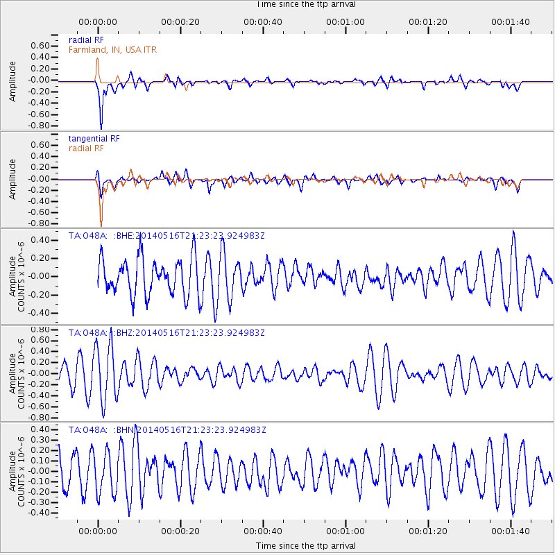
O48A Farmland, IN, USA - Earthquake Result Viewer
*The percent match for this event was below the threshold and hence no stack was calculated.
| Earthquake location: |
Ascension Island Region |
| Earthquake latitude/longitude: |
-10.4/-13.2 |
| Earthquake time(UTC): |
2014/05/16 (136) 21:11:29 GMT |
| Earthquake Depth: |
12 km |
| Earthquake Magnitude: |
4.9 MW |
| Earthquake Catalog/Contributor: |
ISC/ISC |
|
| Network: |
TA USArray Transportable Network (new EarthScope stations) |
| Station: |
O48A Farmland, IN, USA |
| Lat/Lon: |
40.26 N/85.16 W |
| Elevation: |
300 m |
|
| Distance: |
83.3 deg |
| Az: |
312.884 deg |
| Baz: |
109.634 deg |
| Ray Param: |
$rayparam |
*The percent match for this event was below the threshold and hence was not used in the summary stack. |
|
| Radial Match: |
79.34516 % |
| Radial Bump: |
400 |
| Transverse Match: |
57.937756 % |
| Transverse Bump: |
400 |
| SOD ConfigId: |
3390531 |
| Insert Time: |
2019-04-11 22:16:20.313 +0000 |
| GWidth: |
2.5 |
| Max Bumps: |
400 |
| Tol: |
0.001 |
|
Signal To Noise
| Channel | StoN | STA | LTA |
| TA:O48A: :BHZ:20140516T21:23:23.924983Z | 2.5006578 | 5.129914E-7 | 2.0514257E-7 |
| TA:O48A: :BHN:20140516T21:23:23.924983Z | 0.9741698 | 1.9074918E-7 | 1.958069E-7 |
| TA:O48A: :BHE:20140516T21:23:23.924983Z | 1.206176 | 2.3594126E-7 | 1.9561095E-7 |
| Arrivals |
| Ps | |
| PpPs | |
| PsPs/PpSs | |


