You are here: Home > Network List > G - GEOSCOPE Stations List
> Station SCZ Chualar Canyon, Santa Cruz, California, U.S.A. > Earthquake Result Viewer
SCZ Chualar Canyon, Santa Cruz, California, U.S.A. - Earthquake Result Viewer
| Earthquake location: |
Fiji Islands Region |
| Earthquake latitude/longitude: |
-21.0/-179.1 |
| Earthquake time(UTC): |
2001/09/12 (255) 08:48:37 GMT |
| Earthquake Depth: |
608 km |
| Earthquake Magnitude: |
5.7 MB, 6.5 MW, 6.4 MW |
| Earthquake Catalog/Contributor: |
WHDF/NEIC |
|
| Network: |
G GEOSCOPE |
| Station: |
SCZ Chualar Canyon, Santa Cruz, California, U.S.A. |
| Lat/Lon: |
36.60 N/121.40 W |
| Elevation: |
261 m |
|
| Distance: |
79.0 deg |
| Az: |
43.863 deg |
| Baz: |
233.571 deg |
| Ray Param: |
0.04733175 |
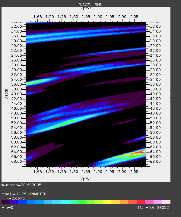
| Estimated Moho Depth: |
63.25 km |
| Estimated Crust Vp/Vs: |
2.10 |
| Assumed Crust Vp: |
6.391 km/s |
| Estimated Crust Vs: |
3.047 km/s |
| Estimated Crust Poisson's Ratio: |
0.35 |
|
| Radial Match: |
80.692085 % |
| Radial Bump: |
400 |
| Transverse Match: |
68.163666 % |
| Transverse Bump: |
400 |
| SOD ConfigId: |
20082 |
| Insert Time: |
2010-02-26 23:52:37.017 +0000 |
| GWidth: |
2.5 |
| Max Bumps: |
400 |
| Tol: |
0.001 |
|
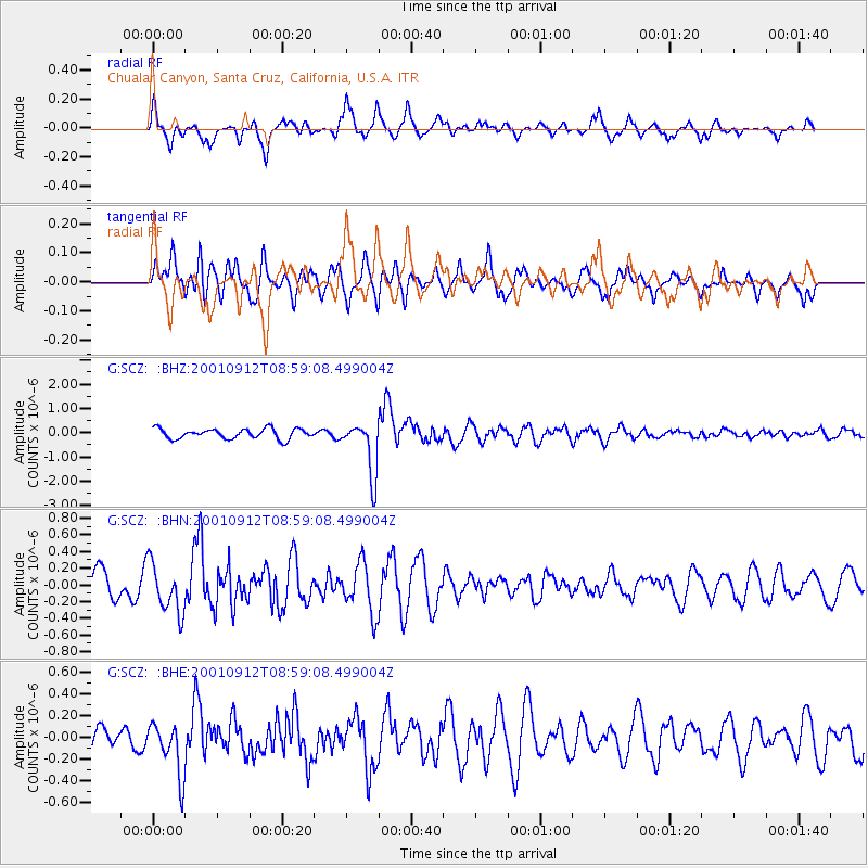
Signal To Noise
| Channel | StoN | STA | LTA |
| G:SCZ: :BHN:20010912T08:59:08.499004Z | 2.2642262 | 2.9641276E-7 | 1.309113E-7 |
| G:SCZ: :BHE:20010912T08:59:08.499004Z | 2.2967792 | 2.4476205E-7 | 1.0656752E-7 |
| G:SCZ: :BHZ:20010912T08:59:08.499004Z | 5.409999 | 1.1193433E-6 | 2.069027E-7 |
| Arrivals |
| Ps | 11 SECOND |
| PpPs | 30 SECOND |
| PsPs/PpSs | 41 SECOND |


