You are here: Home > Network List > TA - USArray Transportable Network (new EarthScope stations) Stations List
> Station U39A Green Forest, AR, USA > Earthquake Result Viewer
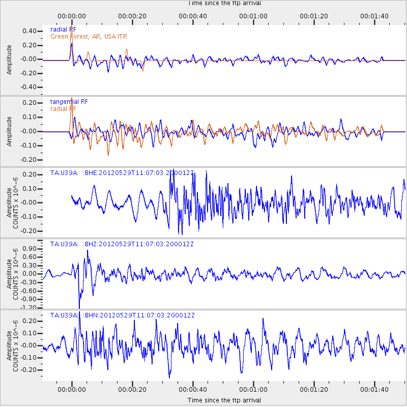
U39A Green Forest, AR, USA - Earthquake Result Viewer
*The percent match for this event was below the threshold and hence no stack was calculated.
| Earthquake location: |
Northern Italy |
| Earthquake latitude/longitude: |
44.9/11.0 |
| Earthquake time(UTC): |
2012/05/29 (150) 10:55:57 GMT |
| Earthquake Depth: |
6.8 km |
| Earthquake Magnitude: |
5.6 MB, 5.3 MS, 5.5 MW, 5.4 MW |
| Earthquake Catalog/Contributor: |
WHDF/NEIC |
|
| Network: |
TA USArray Transportable Network (new EarthScope stations) |
| Station: |
U39A Green Forest, AR, USA |
| Lat/Lon: |
36.38 N/93.48 W |
| Elevation: |
433 m |
|
| Distance: |
74.2 deg |
| Az: |
305.719 deg |
| Baz: |
45.658 deg |
| Ray Param: |
$rayparam |
*The percent match for this event was below the threshold and hence was not used in the summary stack. |
|
| Radial Match: |
52.65762 % |
| Radial Bump: |
400 |
| Transverse Match: |
52.607136 % |
| Transverse Bump: |
400 |
| SOD ConfigId: |
455246 |
| Insert Time: |
2012-09-25 03:27:02.564 +0000 |
| GWidth: |
2.5 |
| Max Bumps: |
400 |
| Tol: |
0.001 |
|
Signal To Noise
| Channel | StoN | STA | LTA |
| TA:U39A: :BHZ:20120529T11:07:03.200012Z | 5.974593 | 4.320906E-7 | 7.2321335E-8 |
| TA:U39A: :BHN:20120529T11:07:03.200012Z | 2.3585641 | 1.06826775E-7 | 4.5293138E-8 |
| TA:U39A: :BHE:20120529T11:07:03.200012Z | 2.1185384 | 1.0471327E-7 | 4.942713E-8 |
| Arrivals |
| Ps | |
| PpPs | |
| PsPs/PpSs | |


