You are here: Home > Network List > G - GEOSCOPE Stations List
> Station SCZ Chualar Canyon, Santa Cruz, California, U.S.A. > Earthquake Result Viewer
SCZ Chualar Canyon, Santa Cruz, California, U.S.A. - Earthquake Result Viewer
| Earthquake location: |
Near Coast Of Central Chile |
| Earthquake latitude/longitude: |
-30.8/-71.1 |
| Earthquake time(UTC): |
2002/06/18 (169) 13:56:22 GMT |
| Earthquake Depth: |
54 km |
| Earthquake Magnitude: |
6.0 MB, 6.6 MW, 6.4 MW |
| Earthquake Catalog/Contributor: |
WHDF/NEIC |
|
| Network: |
G GEOSCOPE |
| Station: |
SCZ Chualar Canyon, Santa Cruz, California, U.S.A. |
| Lat/Lon: |
36.60 N/121.40 W |
| Elevation: |
261 m |
|
| Distance: |
82.0 deg |
| Az: |
321.307 deg |
| Baz: |
138.057 deg |
| Ray Param: |
0.047126528 |
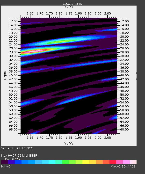
| Estimated Moho Depth: |
27.25 km |
| Estimated Crust Vp/Vs: |
1.67 |
| Assumed Crust Vp: |
6.391 km/s |
| Estimated Crust Vs: |
3.821 km/s |
| Estimated Crust Poisson's Ratio: |
0.22 |
|
| Radial Match: |
92.151955 % |
| Radial Bump: |
400 |
| Transverse Match: |
87.96357 % |
| Transverse Bump: |
400 |
| SOD ConfigId: |
20082 |
| Insert Time: |
2010-02-26 23:52:43.419 +0000 |
| GWidth: |
2.5 |
| Max Bumps: |
400 |
| Tol: |
0.001 |
|
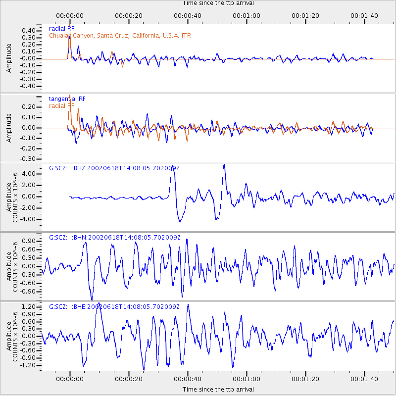
Signal To Noise
| Channel | StoN | STA | LTA |
| G:SCZ: :BHN:20020618T14:08:05.702009Z | 2.3102438 | 2.638726E-7 | 1.14218516E-7 |
| G:SCZ: :BHE:20020618T14:08:05.702009Z | 3.598361 | 4.2641452E-7 | 1.1850243E-7 |
| G:SCZ: :BHZ:20020618T14:08:05.702009Z | 15.204242 | 1.8048544E-6 | 1.187073E-7 |
| Arrivals |
| Ps | 2.9 SECOND |
| PpPs | 11 SECOND |
| PsPs/PpSs | 14 SECOND |


