You are here: Home > Network List > TA - USArray Transportable Network (new EarthScope stations) Stations List
> Station U41A Viola, AR, USA > Earthquake Result Viewer
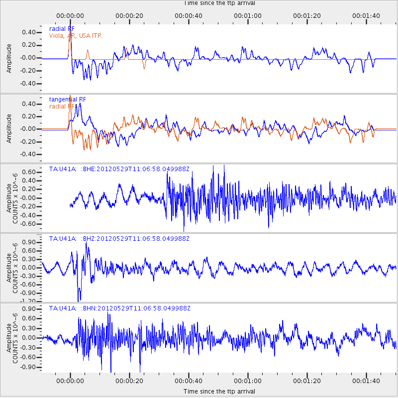
U41A Viola, AR, USA - Earthquake Result Viewer
*The percent match for this event was below the threshold and hence no stack was calculated.
| Earthquake location: |
Northern Italy |
| Earthquake latitude/longitude: |
44.9/11.0 |
| Earthquake time(UTC): |
2012/05/29 (150) 10:55:57 GMT |
| Earthquake Depth: |
6.8 km |
| Earthquake Magnitude: |
5.6 MB, 5.3 MS, 5.5 MW, 5.4 MW |
| Earthquake Catalog/Contributor: |
WHDF/NEIC |
|
| Network: |
TA USArray Transportable Network (new EarthScope stations) |
| Station: |
U41A Viola, AR, USA |
| Lat/Lon: |
36.34 N/91.92 W |
| Elevation: |
300 m |
|
| Distance: |
73.3 deg |
| Az: |
304.779 deg |
| Baz: |
46.317 deg |
| Ray Param: |
$rayparam |
*The percent match for this event was below the threshold and hence was not used in the summary stack. |
|
| Radial Match: |
63.4981 % |
| Radial Bump: |
400 |
| Transverse Match: |
65.22571 % |
| Transverse Bump: |
400 |
| SOD ConfigId: |
455246 |
| Insert Time: |
2012-09-25 03:34:09.575 +0000 |
| GWidth: |
2.5 |
| Max Bumps: |
400 |
| Tol: |
0.001 |
|
Signal To Noise
| Channel | StoN | STA | LTA |
| TA:U41A: :BHZ:20120529T11:06:58.049988Z | 4.878906 | 4.7472983E-7 | 9.7302525E-8 |
| TA:U41A: :BHN:20120529T11:06:58.049988Z | 2.4334877 | 2.569488E-7 | 1.055887E-7 |
| TA:U41A: :BHE:20120529T11:06:58.049988Z | 1.7519368 | 2.2946108E-7 | 1.3097566E-7 |
| Arrivals |
| Ps | |
| PpPs | |
| PsPs/PpSs | |


