You are here: Home > Network List > G - GEOSCOPE Stations List
> Station SCZ Chualar Canyon, Santa Cruz, California, U.S.A. > Earthquake Result Viewer
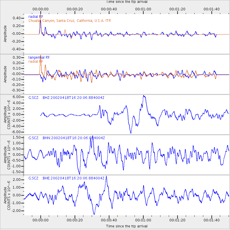
SCZ Chualar Canyon, Santa Cruz, California, U.S.A. - Earthquake Result Viewer

| Earthquake location: |
Near Coast Of Northern Chile |
| Earthquake latitude/longitude: |
-27.5/-70.6 |
| Earthquake time(UTC): |
2002/04/18 (108) 16:08:36 GMT |
| Earthquake Depth: |
62 km |
| Earthquake Magnitude: |
6.2 MB, 6.7 MW, 6.6 MW |
| Earthquake Catalog/Contributor: |
WHDF/NEIC |
|
| Network: |
G GEOSCOPE |
| Station: |
SCZ Chualar Canyon, Santa Cruz, California, U.S.A. |
| Lat/Lon: |
36.60 N/121.40 W |
| Elevation: |
261 m |
|
| Distance: |
79.7 deg |
| Az: |
320.656 deg |
| Baz: |
135.609 deg |
| Ray Param: |
0.048648756 |
| Estimated Moho Depth: |
28.75 km |
| Estimated Crust Vp/Vs: |
1.62 |
| Assumed Crust Vp: |
6.391 km/s |
| Estimated Crust Vs: |
3.933 km/s |
| Estimated Crust Poisson's Ratio: |
0.20 |
|
| Radial Match: |
85.735374 % |
| Radial Bump: |
400 |
| Transverse Match: |
71.511635 % |
| Transverse Bump: |
400 |
| SOD ConfigId: |
20082 |
| Insert Time: |
2010-02-26 23:52:50.969 +0000 |
| GWidth: |
2.5 |
| Max Bumps: |
400 |
| Tol: |
0.001 |
|
Signal To Noise
| Channel | StoN | STA | LTA |
| G:SCZ: :BHN:20020418T16:20:06.884004Z | 1.2940056 | 2.3909254E-7 | 1.8476932E-7 |
| G:SCZ: :BHE:20020418T16:20:06.884004Z | 0.7608286 | 3.84086E-7 | 5.048259E-7 |
| G:SCZ: :BHZ:20020418T16:20:06.884004Z | 3.7116895 | 1.0655973E-6 | 2.8709226E-7 |
| Arrivals |
| Ps | 2.9 SECOND |
| PpPs | 11 SECOND |
| PsPs/PpSs | 14 SECOND |


