You are here: Home > Network List > TA - USArray Transportable Network (new EarthScope stations) Stations List
> Station R43A Red Bud, IL, USA > Earthquake Result Viewer
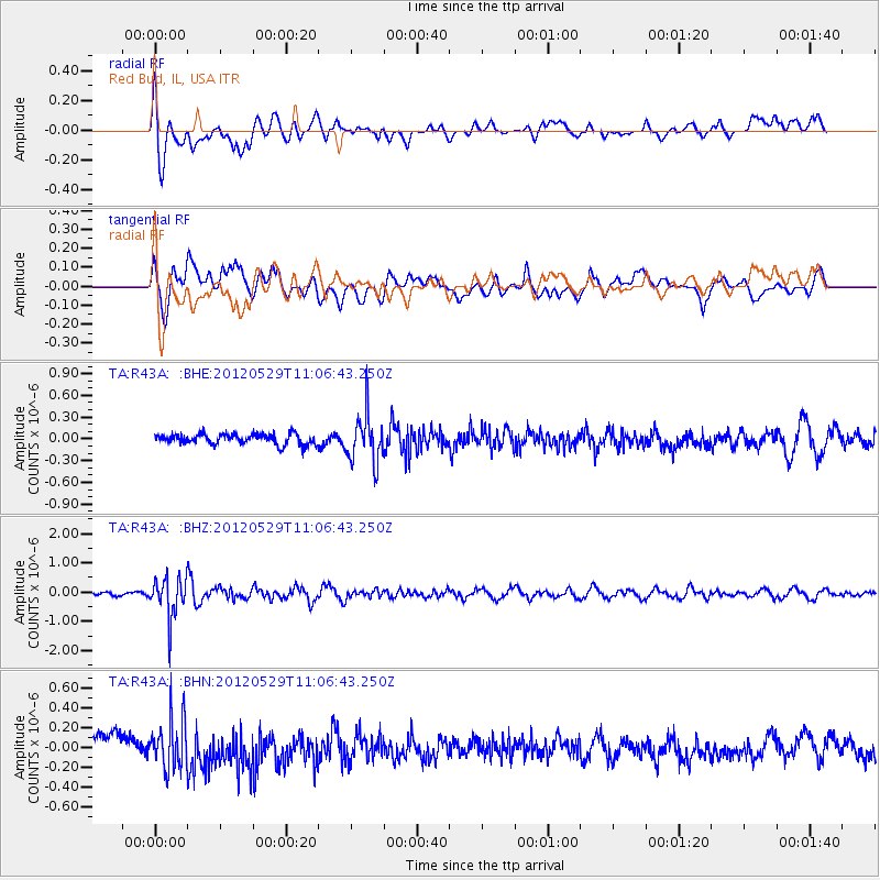
R43A Red Bud, IL, USA - Earthquake Result Viewer
*The percent match for this event was below the threshold and hence no stack was calculated.
| Earthquake location: |
Northern Italy |
| Earthquake latitude/longitude: |
44.9/11.0 |
| Earthquake time(UTC): |
2012/05/29 (150) 10:55:57 GMT |
| Earthquake Depth: |
6.8 km |
| Earthquake Magnitude: |
5.6 MB, 5.3 MS, 5.5 MW, 5.4 MW |
| Earthquake Catalog/Contributor: |
WHDF/NEIC |
|
| Network: |
TA USArray Transportable Network (new EarthScope stations) |
| Station: |
R43A Red Bud, IL, USA |
| Lat/Lon: |
38.28 N/89.93 W |
| Elevation: |
186 m |
|
| Distance: |
70.9 deg |
| Az: |
305.123 deg |
| Baz: |
47.624 deg |
| Ray Param: |
$rayparam |
*The percent match for this event was below the threshold and hence was not used in the summary stack. |
|
| Radial Match: |
74.34181 % |
| Radial Bump: |
400 |
| Transverse Match: |
50.528484 % |
| Transverse Bump: |
400 |
| SOD ConfigId: |
455246 |
| Insert Time: |
2012-09-25 03:35:47.688 +0000 |
| GWidth: |
2.5 |
| Max Bumps: |
400 |
| Tol: |
0.001 |
|
Signal To Noise
| Channel | StoN | STA | LTA |
| TA:R43A: :BHZ:20120529T11:06:43.250Z | 8.9467945 | 6.8724586E-7 | 7.6814764E-8 |
| TA:R43A: :BHN:20120529T11:06:43.250Z | 2.1713505 | 2.447658E-7 | 1.1272515E-7 |
| TA:R43A: :BHE:20120529T11:06:43.250Z | 4.683301 | 3.3633717E-7 | 7.181626E-8 |
| Arrivals |
| Ps | |
| PpPs | |
| PsPs/PpSs | |


