You are here: Home > Network List > TA - USArray Transportable Network (new EarthScope stations) Stations List
> Station E41A Kenton, MI, USA > Earthquake Result Viewer
E41A Kenton, MI, USA - Earthquake Result Viewer
*The percent match for this event was below the threshold and hence no stack was calculated.
| Earthquake location: |
Northern Italy |
| Earthquake latitude/longitude: |
44.9/11.0 |
| Earthquake time(UTC): |
2012/05/29 (150) 10:55:57 GMT |
| Earthquake Depth: |
6.8 km |
| Earthquake Magnitude: |
5.6 MB, 5.3 MS, 5.5 MW, 5.4 MW |
| Earthquake Catalog/Contributor: |
WHDF/NEIC |
|
| Network: |
TA USArray Transportable Network (new EarthScope stations) |
| Station: |
E41A Kenton, MI, USA |
| Lat/Lon: |
46.46 N/88.96 W |
| Elevation: |
377 m |
|
| Distance: |
65.0 deg |
| Az: |
311.29 deg |
| Baz: |
50.598 deg |
| Ray Param: |
$rayparam |
*The percent match for this event was below the threshold and hence was not used in the summary stack. |
|
| Radial Match: |
54.321926 % |
| Radial Bump: |
400 |
| Transverse Match: |
59.965 % |
| Transverse Bump: |
400 |
| SOD ConfigId: |
455246 |
| Insert Time: |
2012-09-25 03:38:20.153 +0000 |
| GWidth: |
2.5 |
| Max Bumps: |
400 |
| Tol: |
0.001 |
|
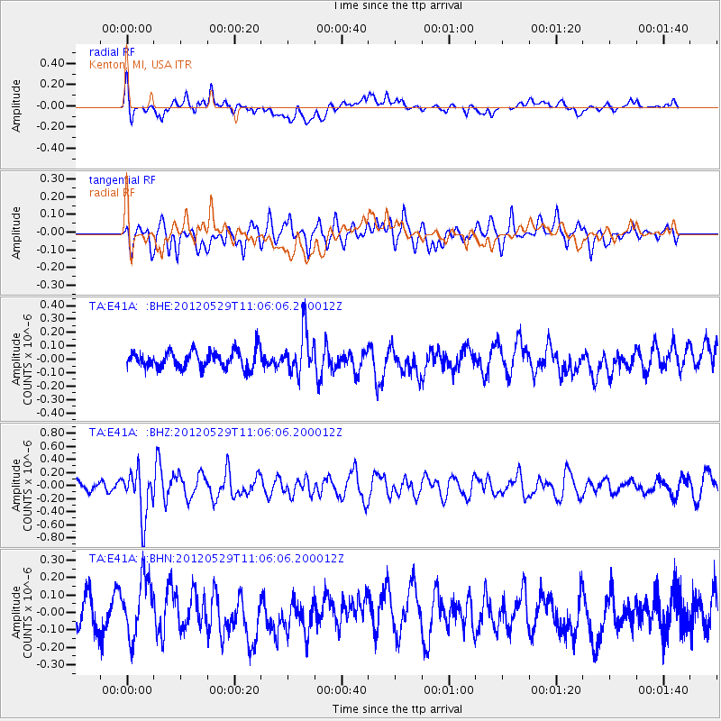
Signal To Noise
| Channel | StoN | STA | LTA |
| TA:E41A: :BHZ:20120529T11:06:06.200012Z | 3.948831 | 3.6015007E-7 | 9.120422E-8 |
| TA:E41A: :BHN:20120529T11:06:06.200012Z | 1.7219118 | 1.687985E-7 | 9.80297E-8 |
| TA:E41A: :BHE:20120529T11:06:06.200012Z | 2.4038107 | 1.5595793E-7 | 6.487946E-8 |
| Arrivals |
| Ps | |
| PpPs | |
| PsPs/PpSs | |


