You are here: Home > Network List > GS - US Geological Survey Networks Stations List
> Station KAN10 Keim Farm > Earthquake Result Viewer
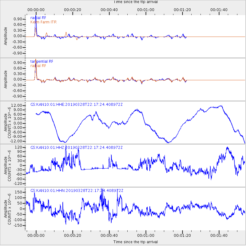
KAN10 Keim Farm - Earthquake Result Viewer
*The percent match for this event was below the threshold and hence no stack was calculated.
| Earthquake location: |
East Of Kuril Islands |
| Earthquake latitude/longitude: |
50.5/160.0 |
| Earthquake time(UTC): |
2019/03/28 (087) 22:06:49 GMT |
| Earthquake Depth: |
9.0 km |
| Earthquake Magnitude: |
6.2 Mww |
| Earthquake Catalog/Contributor: |
NEIC PDE/us |
|
| Network: |
GS US Geological Survey Networks |
| Station: |
KAN10 Keim Farm |
| Lat/Lon: |
37.12 N/98.10 W |
| Elevation: |
417 m |
|
| Distance: |
69.1 deg |
| Az: |
56.835 deg |
| Baz: |
318.025 deg |
| Ray Param: |
$rayparam |
*The percent match for this event was below the threshold and hence was not used in the summary stack. |
|
| Radial Match: |
90.2835 % |
| Radial Bump: |
214 |
| Transverse Match: |
90.63911 % |
| Transverse Bump: |
249 |
| SOD ConfigId: |
3426611 |
| Insert Time: |
2019-04-11 22:17:40.184 +0000 |
| GWidth: |
2.5 |
| Max Bumps: |
400 |
| Tol: |
0.001 |
|
Signal To Noise
| Channel | StoN | STA | LTA |
| GS:KAN10:01:HHZ:20190328T22:17:24.408972Z | 1.1115084 | 5.6961613E-5 | 5.1247127E-5 |
| GS:KAN10:01:HHN:20190328T22:17:24.408972Z | 2.0262408 | 9.472789E-5 | 4.6750556E-5 |
| GS:KAN10:01:HHE:20190328T22:17:24.408972Z | 0.94446284 | 7.153353E-6 | 7.5739918E-6 |
| Arrivals |
| Ps | |
| PpPs | |
| PsPs/PpSs | |


