You are here: Home > Network List > TA - USArray Transportable Network (new EarthScope stations) Stations List
> Station G42A Mountain, WI, USA > Earthquake Result Viewer
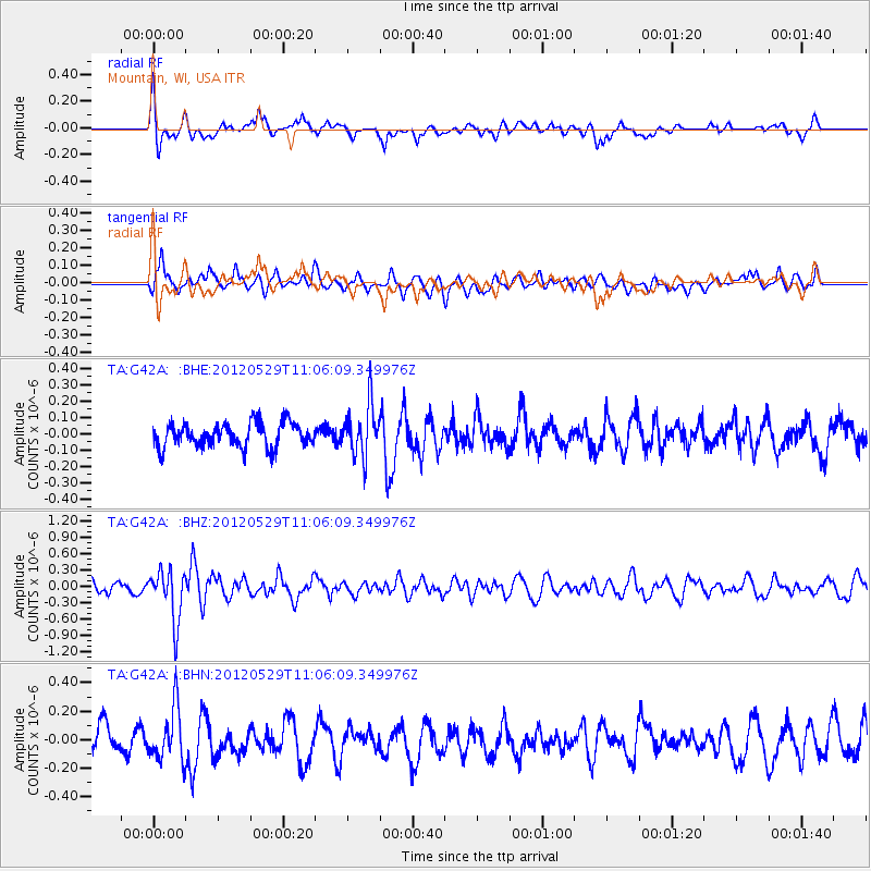
G42A Mountain, WI, USA - Earthquake Result Viewer
*The percent match for this event was below the threshold and hence no stack was calculated.
| Earthquake location: |
Northern Italy |
| Earthquake latitude/longitude: |
44.9/11.0 |
| Earthquake time(UTC): |
2012/05/29 (150) 10:55:57 GMT |
| Earthquake Depth: |
6.8 km |
| Earthquake Magnitude: |
5.6 MB, 5.3 MS, 5.5 MW, 5.4 MW |
| Earthquake Catalog/Contributor: |
WHDF/NEIC |
|
| Network: |
TA USArray Transportable Network (new EarthScope stations) |
| Station: |
G42A Mountain, WI, USA |
| Lat/Lon: |
45.24 N/88.43 W |
| Elevation: |
315 m |
|
| Distance: |
65.5 deg |
| Az: |
309.988 deg |
| Baz: |
50.435 deg |
| Ray Param: |
$rayparam |
*The percent match for this event was below the threshold and hence was not used in the summary stack. |
|
| Radial Match: |
76.44997 % |
| Radial Bump: |
400 |
| Transverse Match: |
54.768875 % |
| Transverse Bump: |
400 |
| SOD ConfigId: |
455246 |
| Insert Time: |
2012-09-25 03:39:35.368 +0000 |
| GWidth: |
2.5 |
| Max Bumps: |
400 |
| Tol: |
0.001 |
|
Signal To Noise
| Channel | StoN | STA | LTA |
| TA:G42A: :BHZ:20120529T11:06:09.349976Z | 5.0445943 | 4.701486E-7 | 9.3198494E-8 |
| TA:G42A: :BHN:20120529T11:06:09.349976Z | 1.9727232 | 1.8445174E-7 | 9.350107E-8 |
| TA:G42A: :BHE:20120529T11:06:09.349976Z | 2.1907883 | 1.5958814E-7 | 7.2845076E-8 |
| Arrivals |
| Ps | |
| PpPs | |
| PsPs/PpSs | |


