You are here: Home > Network List > TA - USArray Transportable Network (new EarthScope stations) Stations List
> Station O44A Mansfield, IL, USA > Earthquake Result Viewer
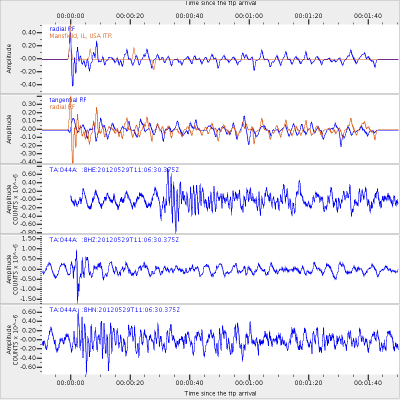
O44A Mansfield, IL, USA - Earthquake Result Viewer
*The percent match for this event was below the threshold and hence no stack was calculated.
| Earthquake location: |
Northern Italy |
| Earthquake latitude/longitude: |
44.9/11.0 |
| Earthquake time(UTC): |
2012/05/29 (150) 10:55:57 GMT |
| Earthquake Depth: |
6.8 km |
| Earthquake Magnitude: |
5.6 MB, 5.3 MS, 5.5 MW, 5.4 MW |
| Earthquake Catalog/Contributor: |
WHDF/NEIC |
|
| Network: |
TA USArray Transportable Network (new EarthScope stations) |
| Station: |
O44A Mansfield, IL, USA |
| Lat/Lon: |
40.15 N/88.47 W |
| Elevation: |
213 m |
|
| Distance: |
68.8 deg |
| Az: |
305.804 deg |
| Baz: |
48.78 deg |
| Ray Param: |
$rayparam |
*The percent match for this event was below the threshold and hence was not used in the summary stack. |
|
| Radial Match: |
74.88414 % |
| Radial Bump: |
400 |
| Transverse Match: |
55.17972 % |
| Transverse Bump: |
400 |
| SOD ConfigId: |
455246 |
| Insert Time: |
2012-09-25 03:40:26.345 +0000 |
| GWidth: |
2.5 |
| Max Bumps: |
400 |
| Tol: |
0.001 |
|
Signal To Noise
| Channel | StoN | STA | LTA |
| TA:O44A: :BHZ:20120529T11:06:30.375Z | 3.1182356 | 5.1728557E-7 | 1.6589047E-7 |
| TA:O44A: :BHN:20120529T11:06:30.375Z | 1.6002302 | 2.1894112E-7 | 1.3681851E-7 |
| TA:O44A: :BHE:20120529T11:06:30.375Z | 2.8543706 | 3.0889316E-7 | 1.08217606E-7 |
| Arrivals |
| Ps | |
| PpPs | |
| PsPs/PpSs | |


