You are here: Home > Network List > G - GEOSCOPE Stations List
> Station SCZ Chualar Canyon, Santa Cruz, California, U.S.A. > Earthquake Result Viewer
SCZ Chualar Canyon, Santa Cruz, California, U.S.A. - Earthquake Result Viewer
| Earthquake location: |
Central Alaska |
| Earthquake latitude/longitude: |
63.5/-147.4 |
| Earthquake time(UTC): |
2002/11/03 (307) 22:12:41 GMT |
| Earthquake Depth: |
4.9 km |
| Earthquake Magnitude: |
7.0 MB, 8.5 MS, 7.9 MW |
| Earthquake Catalog/Contributor: |
WHDF/NEIC |
|
| Network: |
G GEOSCOPE |
| Station: |
SCZ Chualar Canyon, Santa Cruz, California, U.S.A. |
| Lat/Lon: |
36.60 N/121.40 W |
| Elevation: |
261 m |
|
| Distance: |
31.3 deg |
| Az: |
137.098 deg |
| Baz: |
337.713 deg |
| Ray Param: |
0.079121195 |
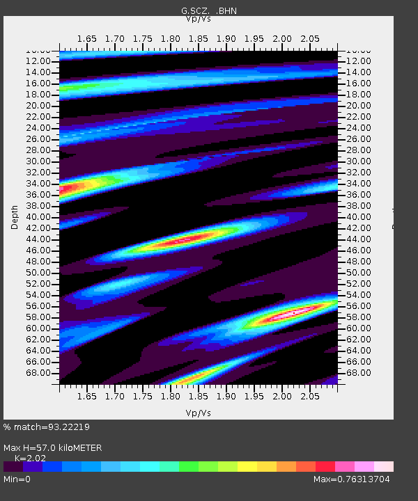
| Estimated Moho Depth: |
57.0 km |
| Estimated Crust Vp/Vs: |
2.02 |
| Assumed Crust Vp: |
6.391 km/s |
| Estimated Crust Vs: |
3.164 km/s |
| Estimated Crust Poisson's Ratio: |
0.34 |
|
| Radial Match: |
93.22219 % |
| Radial Bump: |
306 |
| Transverse Match: |
82.84595 % |
| Transverse Bump: |
400 |
| SOD ConfigId: |
4714 |
| Insert Time: |
2010-02-26 23:53:02.633 +0000 |
| GWidth: |
2.5 |
| Max Bumps: |
400 |
| Tol: |
0.001 |
|

Signal To Noise
| Channel | StoN | STA | LTA |
| G:SCZ: :BHN:20021103T22:18:31.000Z | 8.899579 | 1.5723568E-6 | 1.7667767E-7 |
| G:SCZ: :BHE:20021103T22:18:31.000Z | 7.9158225 | 1.4023929E-6 | 1.7716326E-7 |
| G:SCZ: :BHZ:20021103T22:18:31.000Z | 14.030655 | 4.069713E-6 | 2.9005867E-7 |
| Arrivals |
| Ps | 9.7 SECOND |
| PpPs | 25 SECOND |
| PsPs/PpSs | 35 SECOND |


