You are here: Home > Network List > TA - USArray Transportable Network (new EarthScope stations) Stations List
> Station X46A Booneville, MS, USA > Earthquake Result Viewer
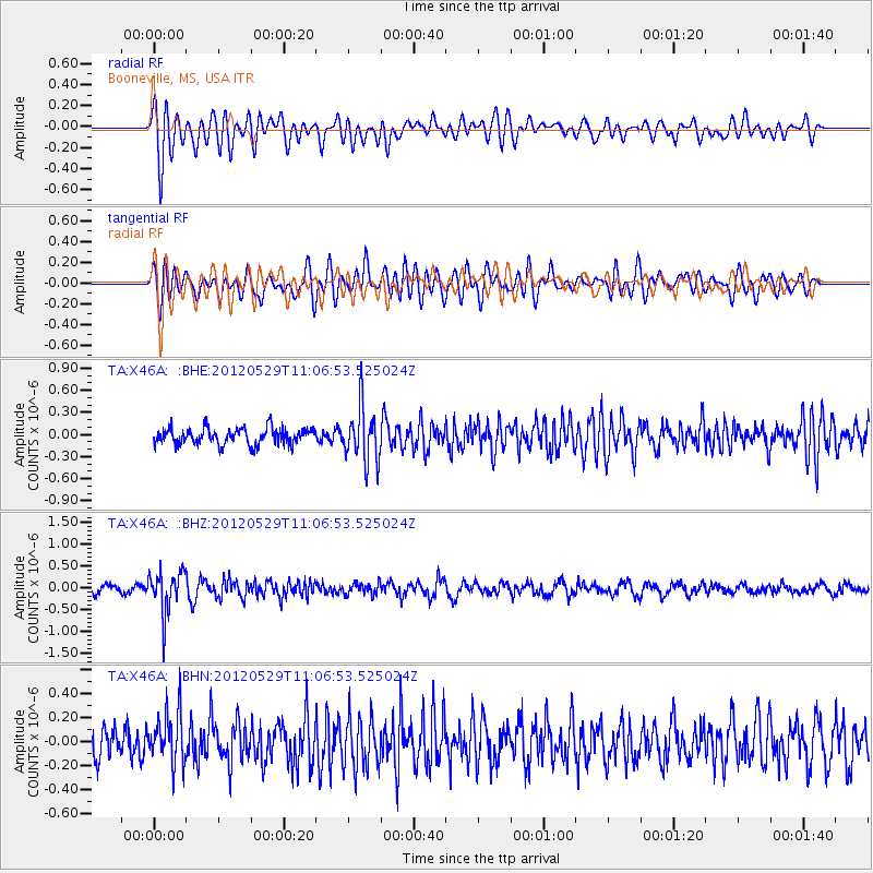
X46A Booneville, MS, USA - Earthquake Result Viewer
*The percent match for this event was below the threshold and hence no stack was calculated.
| Earthquake location: |
Northern Italy |
| Earthquake latitude/longitude: |
44.9/11.0 |
| Earthquake time(UTC): |
2012/05/29 (150) 10:55:57 GMT |
| Earthquake Depth: |
6.8 km |
| Earthquake Magnitude: |
5.6 MB, 5.3 MS, 5.5 MW, 5.4 MW |
| Earthquake Catalog/Contributor: |
WHDF/NEIC |
|
| Network: |
TA USArray Transportable Network (new EarthScope stations) |
| Station: |
X46A Booneville, MS, USA |
| Lat/Lon: |
34.56 N/88.58 W |
| Elevation: |
150 m |
|
| Distance: |
72.6 deg |
| Az: |
301.47 deg |
| Baz: |
47.274 deg |
| Ray Param: |
$rayparam |
*The percent match for this event was below the threshold and hence was not used in the summary stack. |
|
| Radial Match: |
72.37432 % |
| Radial Bump: |
400 |
| Transverse Match: |
72.678795 % |
| Transverse Bump: |
400 |
| SOD ConfigId: |
455246 |
| Insert Time: |
2012-09-25 03:42:48.491 +0000 |
| GWidth: |
2.5 |
| Max Bumps: |
400 |
| Tol: |
0.001 |
|
Signal To Noise
| Channel | StoN | STA | LTA |
| TA:X46A: :BHZ:20120529T11:06:53.525024Z | 4.492686 | 4.8838706E-7 | 1.08707155E-7 |
| TA:X46A: :BHN:20120529T11:06:53.525024Z | 1.8995001 | 2.1233245E-7 | 1.1178333E-7 |
| TA:X46A: :BHE:20120529T11:06:53.525024Z | 3.3687253 | 3.6962524E-7 | 1.0972258E-7 |
| Arrivals |
| Ps | |
| PpPs | |
| PsPs/PpSs | |


