You are here: Home > Network List > TA - USArray Transportable Network (new EarthScope stations) Stations List
> Station W48A Pulaski, TN, USA > Earthquake Result Viewer
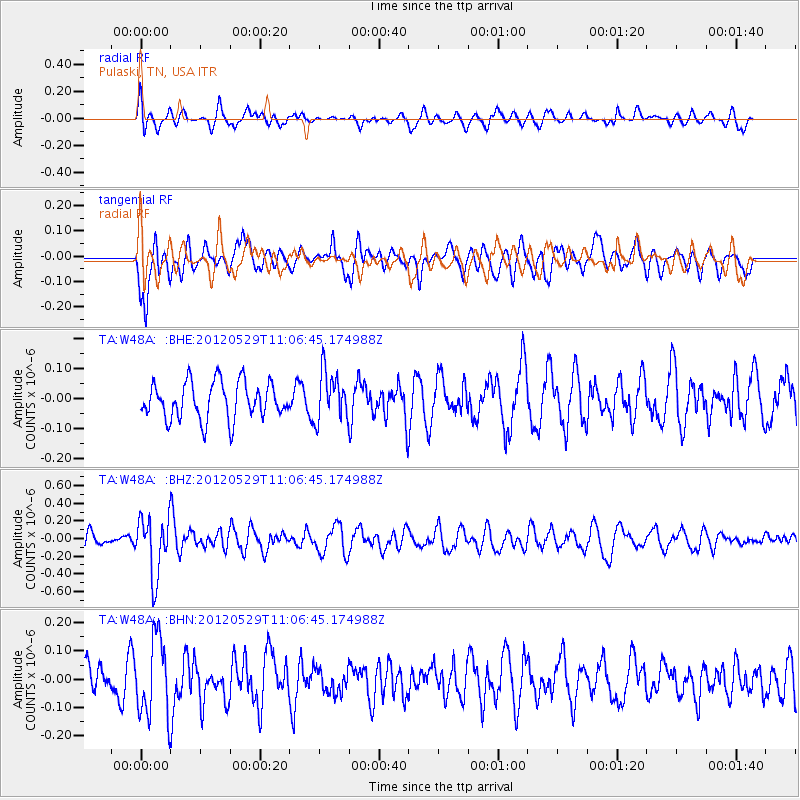
W48A Pulaski, TN, USA - Earthquake Result Viewer
*The percent match for this event was below the threshold and hence no stack was calculated.
| Earthquake location: |
Northern Italy |
| Earthquake latitude/longitude: |
44.9/11.0 |
| Earthquake time(UTC): |
2012/05/29 (150) 10:55:57 GMT |
| Earthquake Depth: |
6.8 km |
| Earthquake Magnitude: |
5.6 MB, 5.3 MS, 5.5 MW, 5.4 MW |
| Earthquake Catalog/Contributor: |
WHDF/NEIC |
|
| Network: |
TA USArray Transportable Network (new EarthScope stations) |
| Station: |
W48A Pulaski, TN, USA |
| Lat/Lon: |
35.14 N/86.93 W |
| Elevation: |
260 m |
|
| Distance: |
71.2 deg |
| Az: |
300.959 deg |
| Baz: |
48.054 deg |
| Ray Param: |
$rayparam |
*The percent match for this event was below the threshold and hence was not used in the summary stack. |
|
| Radial Match: |
58.683353 % |
| Radial Bump: |
400 |
| Transverse Match: |
61.03357 % |
| Transverse Bump: |
400 |
| SOD ConfigId: |
455246 |
| Insert Time: |
2012-09-25 03:44:00.646 +0000 |
| GWidth: |
2.5 |
| Max Bumps: |
400 |
| Tol: |
0.001 |
|
Signal To Noise
| Channel | StoN | STA | LTA |
| TA:W48A: :BHZ:20120529T11:06:45.174988Z | 4.3793883 | 3.3291624E-7 | 7.6018885E-8 |
| TA:W48A: :BHN:20120529T11:06:45.174988Z | 2.6332722 | 1.3713415E-7 | 5.207747E-8 |
| TA:W48A: :BHE:20120529T11:06:45.174988Z | 1.3449037 | 8.212378E-8 | 6.106294E-8 |
| Arrivals |
| Ps | |
| PpPs | |
| PsPs/PpSs | |


