You are here: Home > Network List > GS - US Geological Survey Networks Stations List
> Station OK051 E0350 and S34600 Roads, Ralston, OK > Earthquake Result Viewer
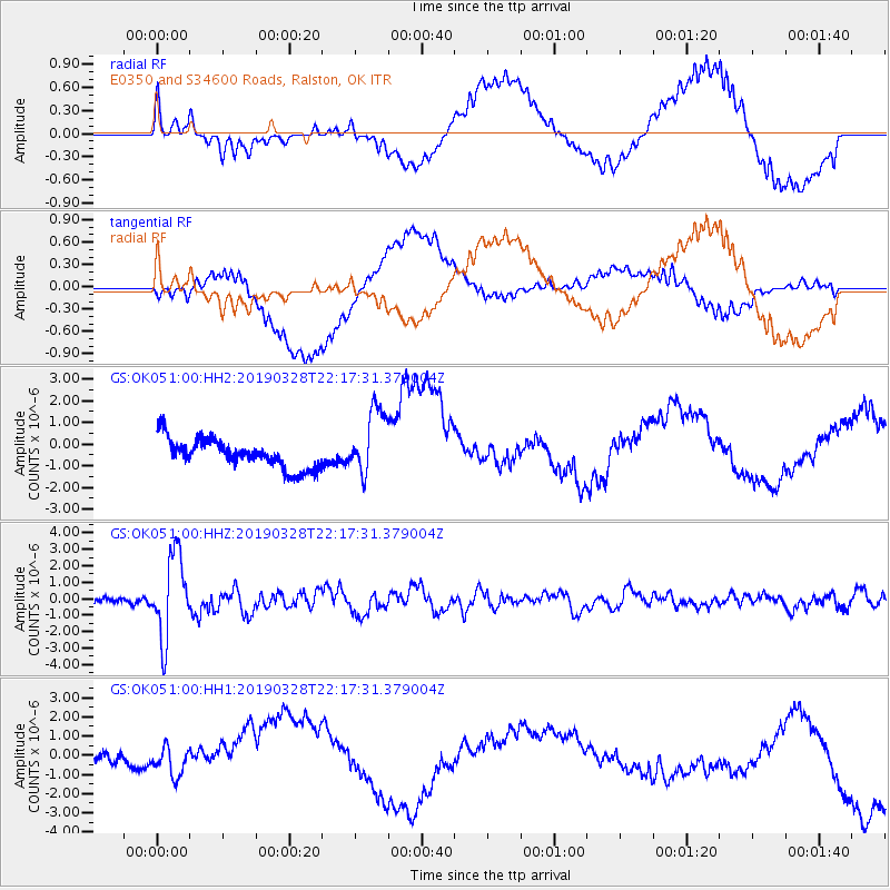
OK051 E0350 and S34600 Roads, Ralston, OK - Earthquake Result Viewer
*The percent match for this event was below the threshold and hence no stack was calculated.
| Earthquake location: |
East Of Kuril Islands |
| Earthquake latitude/longitude: |
50.5/160.0 |
| Earthquake time(UTC): |
2019/03/28 (087) 22:06:49 GMT |
| Earthquake Depth: |
9.0 km |
| Earthquake Magnitude: |
6.2 Mww |
| Earthquake Catalog/Contributor: |
NEIC PDE/us |
|
| Network: |
GS US Geological Survey Networks |
| Station: |
OK051 E0350 and S34600 Roads, Ralston, OK |
| Lat/Lon: |
36.51 N/96.84 W |
| Elevation: |
263 m |
|
| Distance: |
70.2 deg |
| Az: |
56.467 deg |
| Baz: |
318.649 deg |
| Ray Param: |
$rayparam |
*The percent match for this event was below the threshold and hence was not used in the summary stack. |
|
| Radial Match: |
43.121017 % |
| Radial Bump: |
400 |
| Transverse Match: |
47.056423 % |
| Transverse Bump: |
400 |
| SOD ConfigId: |
3426611 |
| Insert Time: |
2019-04-11 22:18:01.107 +0000 |
| GWidth: |
2.5 |
| Max Bumps: |
400 |
| Tol: |
0.001 |
|
Signal To Noise
| Channel | StoN | STA | LTA |
| GS:OK051:00:HHZ:20190328T22:17:31.379004Z | 12.368147 | 2.5128609E-6 | 2.0317196E-7 |
| GS:OK051:00:HH1:20190328T22:17:31.379004Z | 1.4460691 | 1.3985662E-6 | 9.671503E-7 |
| GS:OK051:00:HH2:20190328T22:17:31.379004Z | 2.332261 | 1.5646979E-6 | 6.708931E-7 |
| Arrivals |
| Ps | |
| PpPs | |
| PsPs/PpSs | |


