You are here: Home > Network List > ZJ12 - Transantarctic Mountains Northern Network Stations List
> Station DUBY Mt Kring, Antarctica > Earthquake Result Viewer
DUBY Mt Kring, Antarctica - Earthquake Result Viewer
| Earthquake location: |
Ascension Island Region |
| Earthquake latitude/longitude: |
-10.4/-13.2 |
| Earthquake time(UTC): |
2014/05/16 (136) 21:11:29 GMT |
| Earthquake Depth: |
12 km |
| Earthquake Magnitude: |
4.9 MW |
| Earthquake Catalog/Contributor: |
ISC/ISC |
|
| Network: |
ZJ Transantarctic Mountains Northern Network |
| Station: |
DUBY Mt Kring, Antarctica |
| Lat/Lon: |
74.99 S/158.08 E |
| Elevation: |
1508 m |
|
| Distance: |
94.6 deg |
| Az: |
177.726 deg |
| Baz: |
188.611 deg |
| Ray Param: |
0.041007955 |
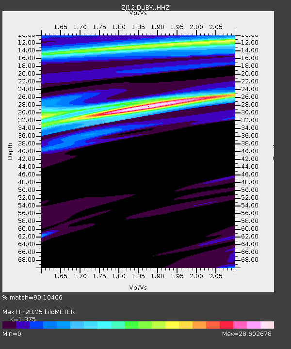
| Estimated Moho Depth: |
28.25 km |
| Estimated Crust Vp/Vs: |
1.88 |
| Assumed Crust Vp: |
6.182 km/s |
| Estimated Crust Vs: |
3.297 km/s |
| Estimated Crust Poisson's Ratio: |
0.30 |
|
| Radial Match: |
90.10406 % |
| Radial Bump: |
262 |
| Transverse Match: |
92.74682 % |
| Transverse Bump: |
217 |
| SOD ConfigId: |
3390531 |
| Insert Time: |
2019-04-11 22:18:54.409 +0000 |
| GWidth: |
2.5 |
| Max Bumps: |
400 |
| Tol: |
0.001 |
|

Signal To Noise
| Channel | StoN | STA | LTA |
| ZJ:DUBY: :HHZ:20140516T21:24:17.85998Z | 2.6396976 | 1.3241522E-6 | 5.0163027E-7 |
| ZJ:DUBY: :HHN:20140516T21:24:17.85998Z | 3.3803368 | 5.2322404E-5 | 1.547846E-5 |
| ZJ:DUBY: :HHE:20140516T21:24:17.85998Z | 3.5470908 | 1.1501879E-4 | 3.2426233E-5 |
| Arrivals |
| Ps | 4.1 SECOND |
| PpPs | 13 SECOND |
| PsPs/PpSs | 17 SECOND |


