You are here: Home > Network List > G - GEOSCOPE Stations List
> Station SCZ Chualar Canyon, Santa Cruz, California, U.S.A. > Earthquake Result Viewer
SCZ Chualar Canyon, Santa Cruz, California, U.S.A. - Earthquake Result Viewer
| Earthquake location: |
Volcano Islands, Japan Region |
| Earthquake latitude/longitude: |
23.9/141.9 |
| Earthquake time(UTC): |
1998/01/01 (001) 06:11:22 GMT |
| Earthquake Depth: |
96 km |
| Earthquake Magnitude: |
6.4 MB, 5.8 MS, 6.8 UNKNOWN, 6.4 MW |
| Earthquake Catalog/Contributor: |
WHDF/NEIC |
|
| Network: |
G GEOSCOPE |
| Station: |
SCZ Chualar Canyon, Santa Cruz, California, U.S.A. |
| Lat/Lon: |
36.60 N/121.40 W |
| Elevation: |
261 m |
|
| Distance: |
81.2 deg |
| Az: |
53.984 deg |
| Baz: |
293.098 deg |
| Ray Param: |
0.047561225 |
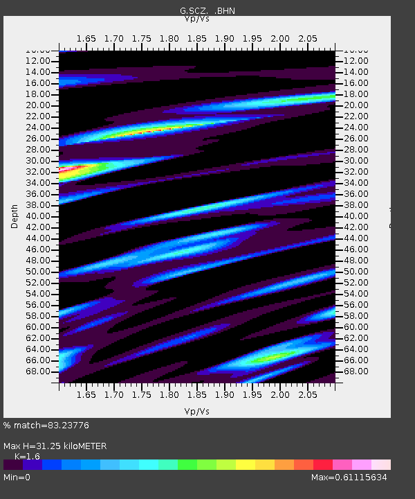
| Estimated Moho Depth: |
31.25 km |
| Estimated Crust Vp/Vs: |
1.60 |
| Assumed Crust Vp: |
6.391 km/s |
| Estimated Crust Vs: |
3.994 km/s |
| Estimated Crust Poisson's Ratio: |
0.18 |
|
| Radial Match: |
83.23776 % |
| Radial Bump: |
388 |
| Transverse Match: |
63.470222 % |
| Transverse Bump: |
400 |
| SOD ConfigId: |
4480 |
| Insert Time: |
2010-02-26 23:53:26.170 +0000 |
| GWidth: |
2.5 |
| Max Bumps: |
400 |
| Tol: |
0.001 |
|

Signal To Noise
| Channel | StoN | STA | LTA |
| G:SCZ: :BHN:19980101T06:22:56.591028Z | 7.2136426 | 2.7461792E-6 | 3.8069243E-7 |
| G:SCZ: :BHE:19980101T06:22:56.591028Z | 1.1021359 | 4.491468E-7 | 4.0752397E-7 |
| G:SCZ: :BHZ:19980101T06:22:56.591028Z | 2.3059454 | 7.461293E-7 | 3.235676E-7 |
| Arrivals |
| Ps | 3.0 SECOND |
| PpPs | 12 SECOND |
| PsPs/PpSs | 15 SECOND |


