You are here: Home > Network List > G - GEOSCOPE Stations List
> Station SCZ Chualar Canyon, Santa Cruz, California, U.S.A. > Earthquake Result Viewer
SCZ Chualar Canyon, Santa Cruz, California, U.S.A. - Earthquake Result Viewer
| Earthquake location: |
Southeast Of Loyalty Islands |
| Earthquake latitude/longitude: |
-22.3/170.9 |
| Earthquake time(UTC): |
1998/01/04 (004) 06:11:58 GMT |
| Earthquake Depth: |
101 km |
| Earthquake Magnitude: |
6.4 MB, 7.4 UNKNOWN, 7.3 ME |
| Earthquake Catalog/Contributor: |
WHDF/NEIC |
|
| Network: |
G GEOSCOPE |
| Station: |
SCZ Chualar Canyon, Santa Cruz, California, U.S.A. |
| Lat/Lon: |
36.60 N/121.40 W |
| Elevation: |
261 m |
|
| Distance: |
86.6 deg |
| Az: |
48.227 deg |
| Baz: |
239.12 deg |
| Ray Param: |
0.043707423 |
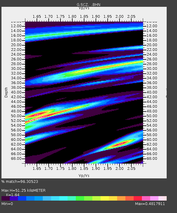
| Estimated Moho Depth: |
51.25 km |
| Estimated Crust Vp/Vs: |
1.64 |
| Assumed Crust Vp: |
6.391 km/s |
| Estimated Crust Vs: |
3.897 km/s |
| Estimated Crust Poisson's Ratio: |
0.20 |
|
| Radial Match: |
96.30523 % |
| Radial Bump: |
389 |
| Transverse Match: |
90.108986 % |
| Transverse Bump: |
400 |
| SOD ConfigId: |
4480 |
| Insert Time: |
2010-02-26 23:53:29.083 +0000 |
| GWidth: |
2.5 |
| Max Bumps: |
400 |
| Tol: |
0.001 |
|

Signal To Noise
| Channel | StoN | STA | LTA |
| G:SCZ: :BHN:19980104T06:23:59.884009Z | 2.3313553 | 7.329483E-7 | 3.1438722E-7 |
| G:SCZ: :BHE:19980104T06:23:59.884009Z | 1.4116664 | 3.5317117E-7 | 2.5018034E-7 |
| G:SCZ: :BHZ:19980104T06:23:59.884009Z | 1.3021638 | 3.7361656E-7 | 2.8691977E-7 |
| Arrivals |
| Ps | 5.3 SECOND |
| PpPs | 21 SECOND |
| PsPs/PpSs | 26 SECOND |


