You are here: Home > Network List > G - GEOSCOPE Stations List
> Station SCZ Chualar Canyon, Santa Cruz, California, U.S.A. > Earthquake Result Viewer
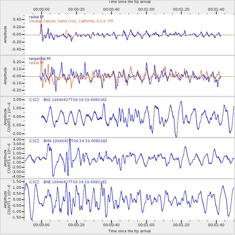
SCZ Chualar Canyon, Santa Cruz, California, U.S.A. - Earthquake Result Viewer
*The percent match for this event was below the threshold and hence no stack was calculated.
| Earthquake location: |
Tonga Islands |
| Earthquake latitude/longitude: |
-21.5/-173.7 |
| Earthquake time(UTC): |
1994/04/27 (117) 09:23:27 GMT |
| Earthquake Depth: |
35 km |
| Earthquake Magnitude: |
6.2 MB, 6.1 MS, 6.0 UNKNOWN, 6.4 MW |
| Earthquake Catalog/Contributor: |
WHDF/NEIC |
|
| Network: |
G GEOSCOPE |
| Station: |
SCZ Chualar Canyon, Santa Cruz, California, U.S.A. |
| Lat/Lon: |
36.60 N/121.40 W |
| Elevation: |
261 m |
|
| Distance: |
76.0 deg |
| Az: |
41.02 deg |
| Baz: |
229.43 deg |
| Ray Param: |
$rayparam |
*The percent match for this event was below the threshold and hence was not used in the summary stack. |
|
| Radial Match: |
42.131145 % |
| Radial Bump: |
329 |
| Transverse Match: |
56.538372 % |
| Transverse Bump: |
345 |
| SOD ConfigId: |
4480 |
| Insert Time: |
2010-02-26 23:53:36.481 +0000 |
| GWidth: |
2.5 |
| Max Bumps: |
400 |
| Tol: |
0.001 |
|
Signal To Noise
| Channel | StoN | STA | LTA |
| G:SCZ: :BHN:19940427T09:34:39.668018Z | 2.808899 | 1.3784659E-6 | 4.907495E-7 |
| G:SCZ: :BHE:19940427T09:34:39.668018Z | 0.54560643 | 4.507807E-7 | 8.262012E-7 |
| G:SCZ: :BHZ:19940427T09:34:39.668018Z | 0.57150155 | 3.325622E-7 | 5.819095E-7 |
| Arrivals |
| Ps | |
| PpPs | |
| PsPs/PpSs | |


