You are here: Home > Network List > TA - USArray Transportable Network (new EarthScope stations) Stations List
> Station C36A Pine Crest Fram, Angora, MN, USA > Earthquake Result Viewer
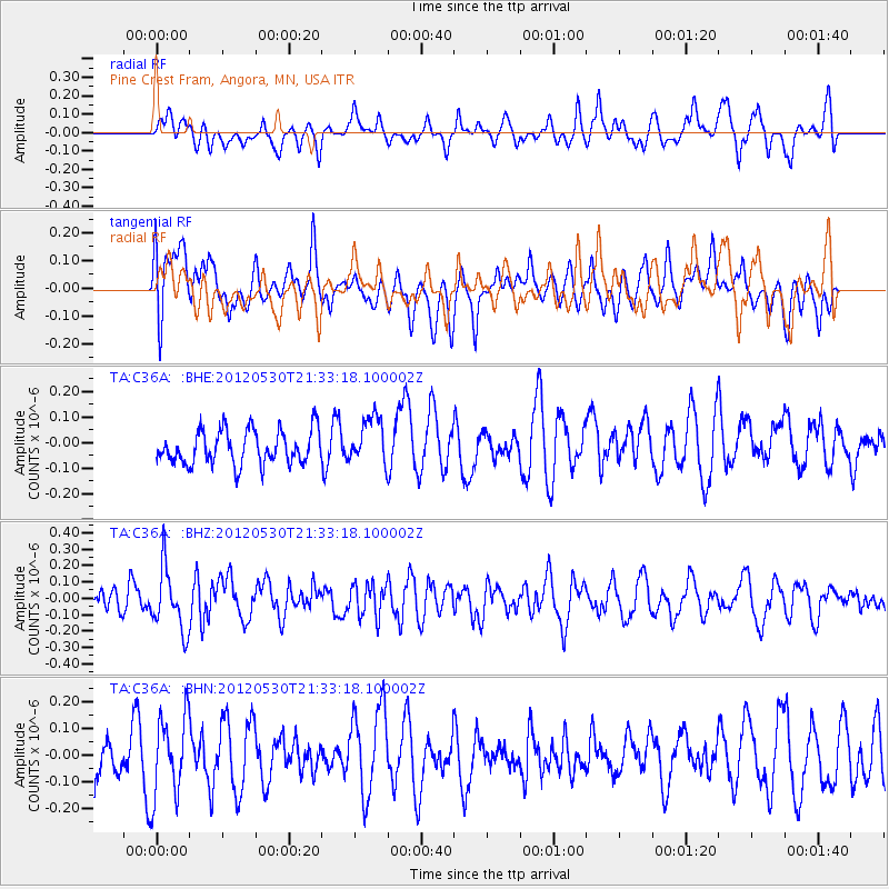
C36A Pine Crest Fram, Angora, MN, USA - Earthquake Result Viewer
*The percent match for this event was below the threshold and hence no stack was calculated.
| Earthquake location: |
Lake Issyk-Kul Region |
| Earthquake latitude/longitude: |
43.4/78.7 |
| Earthquake time(UTC): |
2012/05/30 (151) 21:20:56 GMT |
| Earthquake Depth: |
17 km |
| Earthquake Magnitude: |
5.7 MB, 5.4 MW, 5.3 MW |
| Earthquake Catalog/Contributor: |
WHDF/NEIC |
|
| Network: |
TA USArray Transportable Network (new EarthScope stations) |
| Station: |
C36A Pine Crest Fram, Angora, MN, USA |
| Lat/Lon: |
47.76 N/92.84 W |
| Elevation: |
410 m |
|
| Distance: |
88.9 deg |
| Az: |
354.331 deg |
| Baz: |
6.127 deg |
| Ray Param: |
$rayparam |
*The percent match for this event was below the threshold and hence was not used in the summary stack. |
|
| Radial Match: |
39.086823 % |
| Radial Bump: |
400 |
| Transverse Match: |
47.91733 % |
| Transverse Bump: |
400 |
| SOD ConfigId: |
455246 |
| Insert Time: |
2012-09-25 04:04:15.099 +0000 |
| GWidth: |
2.5 |
| Max Bumps: |
400 |
| Tol: |
0.001 |
|
Signal To Noise
| Channel | StoN | STA | LTA |
| TA:C36A: :BHZ:20120530T21:33:18.100002Z | 2.0880413 | 1.9046072E-7 | 9.121502E-8 |
| TA:C36A: :BHN:20120530T21:33:18.100002Z | 1.0816993 | 1.5067742E-7 | 1.3929696E-7 |
| TA:C36A: :BHE:20120530T21:33:18.100002Z | 1.4177389 | 9.3379036E-8 | 6.586477E-8 |
| Arrivals |
| Ps | |
| PpPs | |
| PsPs/PpSs | |


