You are here: Home > Network List > G - GEOSCOPE Stations List
> Station SCZ Chualar Canyon, Santa Cruz, California, U.S.A. > Earthquake Result Viewer
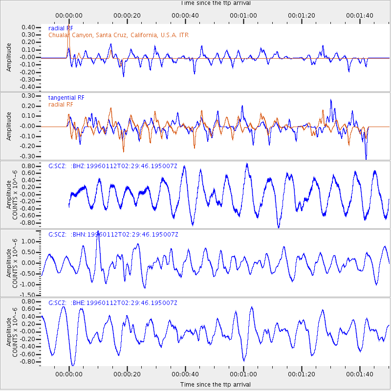
SCZ Chualar Canyon, Santa Cruz, California, U.S.A. - Earthquake Result Viewer
*The percent match for this event was below the threshold and hence no stack was calculated.
| Earthquake location: |
Southeast Of Loyalty Islands |
| Earthquake latitude/longitude: |
-23.2/170.8 |
| Earthquake time(UTC): |
1996/01/12 (012) 02:17:34 GMT |
| Earthquake Depth: |
33 km |
| Earthquake Magnitude: |
5.8 MB, 5.5 MS, 5.5 UNKNOWN, 6.0 MW |
| Earthquake Catalog/Contributor: |
WHDF/NEIC |
|
| Network: |
G GEOSCOPE |
| Station: |
SCZ Chualar Canyon, Santa Cruz, California, U.S.A. |
| Lat/Lon: |
36.60 N/121.40 W |
| Elevation: |
261 m |
|
| Distance: |
87.3 deg |
| Az: |
48.25 deg |
| Baz: |
238.54 deg |
| Ray Param: |
$rayparam |
*The percent match for this event was below the threshold and hence was not used in the summary stack. |
|
| Radial Match: |
50.71975 % |
| Radial Bump: |
353 |
| Transverse Match: |
62.19997 % |
| Transverse Bump: |
332 |
| SOD ConfigId: |
4480 |
| Insert Time: |
2010-02-26 23:53:43.005 +0000 |
| GWidth: |
2.5 |
| Max Bumps: |
400 |
| Tol: |
0.001 |
|
Signal To Noise
| Channel | StoN | STA | LTA |
| G:SCZ: :BHN:19960112T02:29:46.195007Z | 1.3391376 | 3.4147996E-7 | 2.5499992E-7 |
| G:SCZ: :BHE:19960112T02:29:46.195007Z | 2.0171425 | 5.687225E-7 | 2.8194464E-7 |
| G:SCZ: :BHZ:19960112T02:29:46.195007Z | 1.4659262 | 3.1227972E-7 | 2.1302554E-7 |
| Arrivals |
| Ps | |
| PpPs | |
| PsPs/PpSs | |


