You are here: Home > Network List > N4 - Central and EAstern US Network Stations List
> Station L64A Middleborough, MA, USA > Earthquake Result Viewer
L64A Middleborough, MA, USA - Earthquake Result Viewer
| Earthquake location: |
East Of Kuril Islands |
| Earthquake latitude/longitude: |
50.5/160.0 |
| Earthquake time(UTC): |
2019/03/28 (087) 22:06:49 GMT |
| Earthquake Depth: |
9.0 km |
| Earthquake Magnitude: |
6.2 Mww |
| Earthquake Catalog/Contributor: |
NEIC PDE/us |
|
| Network: |
N4 Central and EAstern US Network |
| Station: |
L64A Middleborough, MA, USA |
| Lat/Lon: |
41.94 N/70.84 W |
| Elevation: |
17 m |
|
| Distance: |
77.8 deg |
| Az: |
36.269 deg |
| Baz: |
329.581 deg |
| Ray Param: |
0.05007498 |
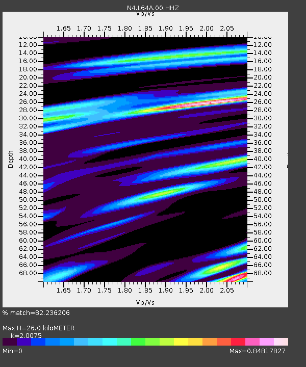
| Estimated Moho Depth: |
26.0 km |
| Estimated Crust Vp/Vs: |
2.01 |
| Assumed Crust Vp: |
6.472 km/s |
| Estimated Crust Vs: |
3.224 km/s |
| Estimated Crust Poisson's Ratio: |
0.33 |
|
| Radial Match: |
82.236206 % |
| Radial Bump: |
400 |
| Transverse Match: |
56.79761 % |
| Transverse Bump: |
400 |
| SOD ConfigId: |
3426611 |
| Insert Time: |
2019-04-11 22:20:50.974 +0000 |
| GWidth: |
2.5 |
| Max Bumps: |
400 |
| Tol: |
0.001 |
|

Signal To Noise
| Channel | StoN | STA | LTA |
| N4:L64A:00:HHZ:20190328T22:18:15.579993Z | 10.222579 | 2.6071996E-6 | 2.5504323E-7 |
| N4:L64A:00:HH1:20190328T22:18:15.579993Z | 6.297586 | 8.7487194E-7 | 1.3892179E-7 |
| N4:L64A:00:HH2:20190328T22:18:15.579993Z | 3.545358 | 5.0629245E-7 | 1.4280432E-7 |
| Arrivals |
| Ps | 4.2 SECOND |
| PpPs | 12 SECOND |
| PsPs/PpSs | 16 SECOND |


