You are here: Home > Network List > N4 - Central and EAstern US Network Stations List
> Station N47A Urbana, IN, USA > Earthquake Result Viewer
N47A Urbana, IN, USA - Earthquake Result Viewer
| Earthquake location: |
East Of Kuril Islands |
| Earthquake latitude/longitude: |
50.5/160.0 |
| Earthquake time(UTC): |
2019/03/28 (087) 22:06:49 GMT |
| Earthquake Depth: |
9.0 km |
| Earthquake Magnitude: |
6.2 Mww |
| Earthquake Catalog/Contributor: |
NEIC PDE/us |
|
| Network: |
N4 Central and EAstern US Network |
| Station: |
N47A Urbana, IN, USA |
| Lat/Lon: |
40.88 N/85.69 W |
| Elevation: |
252 m |
|
| Distance: |
72.4 deg |
| Az: |
46.445 deg |
| Baz: |
322.386 deg |
| Ray Param: |
0.053677578 |
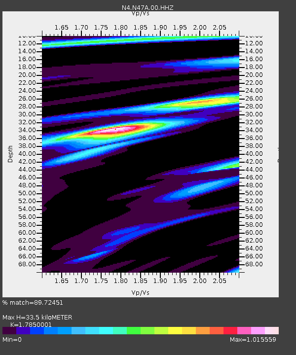
| Estimated Moho Depth: |
33.5 km |
| Estimated Crust Vp/Vs: |
1.79 |
| Assumed Crust Vp: |
6.498 km/s |
| Estimated Crust Vs: |
3.64 km/s |
| Estimated Crust Poisson's Ratio: |
0.27 |
|
| Radial Match: |
89.72451 % |
| Radial Bump: |
400 |
| Transverse Match: |
80.38438 % |
| Transverse Bump: |
400 |
| SOD ConfigId: |
3426611 |
| Insert Time: |
2019-04-11 22:21:06.220 +0000 |
| GWidth: |
2.5 |
| Max Bumps: |
400 |
| Tol: |
0.001 |
|

Signal To Noise
| Channel | StoN | STA | LTA |
| N4:N47A:00:HHZ:20190328T22:17:44.579016Z | 17.757406 | 2.9533962E-6 | 1.6631911E-7 |
| N4:N47A:00:HH1:20190328T22:17:44.579016Z | 5.287912 | 8.936128E-7 | 1.6899163E-7 |
| N4:N47A:00:HH2:20190328T22:17:44.579016Z | 5.050535 | 7.783983E-7 | 1.5412193E-7 |
| Arrivals |
| Ps | 4.2 SECOND |
| PpPs | 14 SECOND |
| PsPs/PpSs | 18 SECOND |


