You are here: Home > Network List > TA - USArray Transportable Network (new EarthScope stations) Stations List
> Station TOLK Tollok Lake Research Station, AK, USA > Earthquake Result Viewer
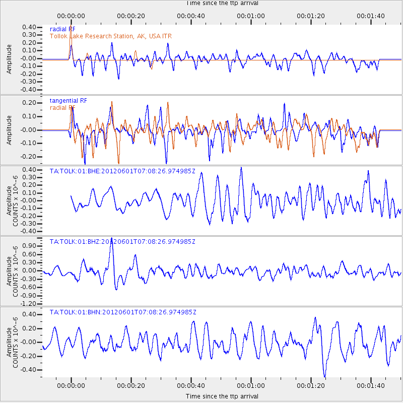
TOLK Tollok Lake Research Station, AK, USA - Earthquake Result Viewer
*The percent match for this event was below the threshold and hence no stack was calculated.
| Earthquake location: |
Irian Jaya Region, Indonesia |
| Earthquake latitude/longitude: |
-0.7/133.3 |
| Earthquake time(UTC): |
2012/06/01 (153) 06:56:20 GMT |
| Earthquake Depth: |
25 km |
| Earthquake Magnitude: |
5.8 MB, 5.6 MS, 5.8 MW, 5.7 MW |
| Earthquake Catalog/Contributor: |
WHDF/NEIC |
|
| Network: |
TA USArray Transportable Network (new EarthScope stations) |
| Station: |
TOLK Tollok Lake Research Station, AK, USA |
| Lat/Lon: |
68.64 N/149.57 W |
| Elevation: |
760 m |
|
| Distance: |
86.0 deg |
| Az: |
20.981 deg |
| Baz: |
257.768 deg |
| Ray Param: |
$rayparam |
*The percent match for this event was below the threshold and hence was not used in the summary stack. |
|
| Radial Match: |
69.01827 % |
| Radial Bump: |
400 |
| Transverse Match: |
70.922455 % |
| Transverse Bump: |
400 |
| SOD ConfigId: |
455246 |
| Insert Time: |
2012-09-25 04:28:26.512 +0000 |
| GWidth: |
2.5 |
| Max Bumps: |
400 |
| Tol: |
0.001 |
|
Signal To Noise
| Channel | StoN | STA | LTA |
| TA:TOLK:01:BHZ:20120601T07:08:26.974985Z | 3.215367 | 2.34814E-7 | 7.302867E-8 |
| TA:TOLK:01:BHN:20120601T07:08:26.974985Z | 2.0282328 | 1.2783322E-7 | 6.3026896E-8 |
| TA:TOLK:01:BHE:20120601T07:08:26.974985Z | 1.5373116 | 1.3368118E-7 | 8.695777E-8 |
| Arrivals |
| Ps | |
| PpPs | |
| PsPs/PpSs | |


