You are here: Home > Network List > N4 - Central and EAstern US Network Stations List
> Station SPMN Marine on St. Croix, MN, USA > Earthquake Result Viewer
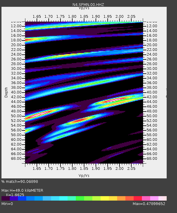
SPMN Marine on St. Croix, MN, USA - Earthquake Result Viewer
| Earthquake location: |
East Of Kuril Islands |
| Earthquake latitude/longitude: |
50.5/160.0 |
| Earthquake time(UTC): |
2019/03/28 (087) 22:06:49 GMT |
| Earthquake Depth: |
9.0 km |
| Earthquake Magnitude: |
6.2 Mww |
| Earthquake Catalog/Contributor: |
NEIC PDE/us |
|
| Network: |
N4 Central and EAstern US Network |
| Station: |
SPMN Marine on St. Croix, MN, USA |
| Lat/Lon: |
45.22 N/92.80 W |
| Elevation: |
311 m |
|
| Distance: |
65.7 deg |
| Az: |
47.759 deg |
| Baz: |
318.013 deg |
| Ray Param: |
0.058070686 |
| Estimated Moho Depth: |
49.0 km |
| Estimated Crust Vp/Vs: |
1.66 |
| Assumed Crust Vp: |
6.571 km/s |
| Estimated Crust Vs: |
3.952 km/s |
| Estimated Crust Poisson's Ratio: |
0.22 |
|
| Radial Match: |
90.06898 % |
| Radial Bump: |
342 |
| Transverse Match: |
68.5919 % |
| Transverse Bump: |
400 |
| SOD ConfigId: |
3426611 |
| Insert Time: |
2019-04-11 22:21:49.200 +0000 |
| GWidth: |
2.5 |
| Max Bumps: |
400 |
| Tol: |
0.001 |
|

Signal To Noise
| Channel | StoN | STA | LTA |
| N4:SPMN:00:HHZ:20190328T22:17:03.300024Z | 22.499794 | 3.4896627E-6 | 1.5509754E-7 |
| N4:SPMN:00:HH1:20190328T22:17:03.300024Z | 11.361063 | 1.5084555E-6 | 1.3277415E-7 |
| N4:SPMN:00:HH2:20190328T22:17:03.300024Z | 7.3490562 | 1.1548077E-6 | 1.5713687E-7 |
| Arrivals |
| Ps | 5.2 SECOND |
| PpPs | 19 SECOND |
| PsPs/PpSs | 24 SECOND |


