You are here: Home > Network List > N4 - Central and EAstern US Network Stations List
> Station T42B T42B > Earthquake Result Viewer
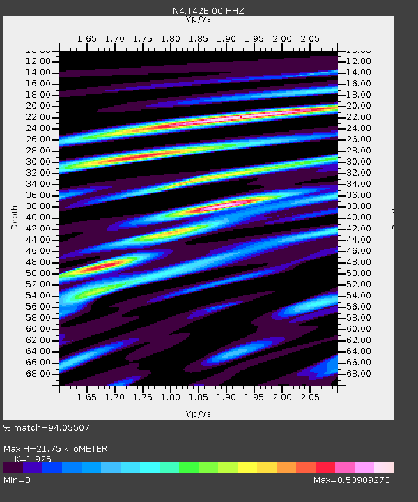
T42B T42B - Earthquake Result Viewer
| Earthquake location: |
East Of Kuril Islands |
| Earthquake latitude/longitude: |
50.5/160.0 |
| Earthquake time(UTC): |
2019/03/28 (087) 22:06:49 GMT |
| Earthquake Depth: |
9.0 km |
| Earthquake Magnitude: |
6.2 Mww |
| Earthquake Catalog/Contributor: |
NEIC PDE/us |
|
| Network: |
N4 Central and EAstern US Network |
| Station: |
T42B T42B |
| Lat/Lon: |
37.03 N/91.09 W |
| Elevation: |
165 m |
|
| Distance: |
72.8 deg |
| Az: |
52.402 deg |
| Baz: |
320.784 deg |
| Ray Param: |
0.053418722 |
| Estimated Moho Depth: |
21.75 km |
| Estimated Crust Vp/Vs: |
1.92 |
| Assumed Crust Vp: |
6.53 km/s |
| Estimated Crust Vs: |
3.392 km/s |
| Estimated Crust Poisson's Ratio: |
0.32 |
|
| Radial Match: |
94.05507 % |
| Radial Bump: |
389 |
| Transverse Match: |
86.74754 % |
| Transverse Bump: |
400 |
| SOD ConfigId: |
3426611 |
| Insert Time: |
2019-04-11 22:22:47.418 +0000 |
| GWidth: |
2.5 |
| Max Bumps: |
400 |
| Tol: |
0.001 |
|

Signal To Noise
| Channel | StoN | STA | LTA |
| N4:T42B:00:HHZ:20190328T22:17:46.918005Z | 24.270847 | 3.1114878E-6 | 1.2819856E-7 |
| N4:T42B:00:HH1:20190328T22:17:46.918005Z | 11.840336 | 1.0837639E-6 | 9.153151E-8 |
| N4:T42B:00:HH2:20190328T22:17:46.918005Z | 10.478522 | 1.0825179E-6 | 1.0330825E-7 |
| Arrivals |
| Ps | 3.2 SECOND |
| PpPs | 9.4 SECOND |
| PsPs/PpSs | 13 SECOND |


