You are here: Home > Network List > TA - USArray Transportable Network (new EarthScope stations) Stations List
> Station Q56A Snyder Ridge, Maysville, WV, USA > Earthquake Result Viewer
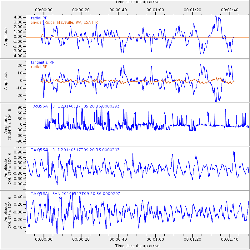
Q56A Snyder Ridge, Maysville, WV, USA - Earthquake Result Viewer
*The percent match for this event was below the threshold and hence no stack was calculated.
| Earthquake location: |
Near Coast Of Northern Chile |
| Earthquake latitude/longitude: |
-20.0/-70.9 |
| Earthquake time(UTC): |
2014/05/17 (137) 09:11:06 GMT |
| Earthquake Depth: |
13 km |
| Earthquake Magnitude: |
5.5 MB |
| Earthquake Catalog/Contributor: |
NEIC PDE/NEIC COMCAT |
|
| Network: |
TA USArray Transportable Network (new EarthScope stations) |
| Station: |
Q56A Snyder Ridge, Maysville, WV, USA |
| Lat/Lon: |
39.04 N/79.19 W |
| Elevation: |
430 m |
|
| Distance: |
59.3 deg |
| Az: |
352.498 deg |
| Baz: |
170.93 deg |
| Ray Param: |
$rayparam |
*The percent match for this event was below the threshold and hence was not used in the summary stack. |
|
| Radial Match: |
51.77297 % |
| Radial Bump: |
400 |
| Transverse Match: |
52.05101 % |
| Transverse Bump: |
400 |
| SOD ConfigId: |
3390531 |
| Insert Time: |
2019-04-11 22:23:46.876 +0000 |
| GWidth: |
2.5 |
| Max Bumps: |
400 |
| Tol: |
0.001 |
|
Signal To Noise
| Channel | StoN | STA | LTA |
| TA:Q56A: :BHZ:20140517T09:20:36.000029Z | 1.6030353 | 3.8649304E-7 | 2.4110076E-7 |
| TA:Q56A: :BHN:20140517T09:20:36.000029Z | 1.1638452 | 2.0763885E-7 | 1.7840762E-7 |
| TA:Q56A: :BHE:20140517T09:20:36.000029Z | 1.2248391 | 3.3984285E-5 | 2.7745918E-5 |
| Arrivals |
| Ps | |
| PpPs | |
| PsPs/PpSs | |


