You are here: Home > Network List > G - GEOSCOPE Stations List
> Station SCZ Chualar Canyon, Santa Cruz, California, U.S.A. > Earthquake Result Viewer
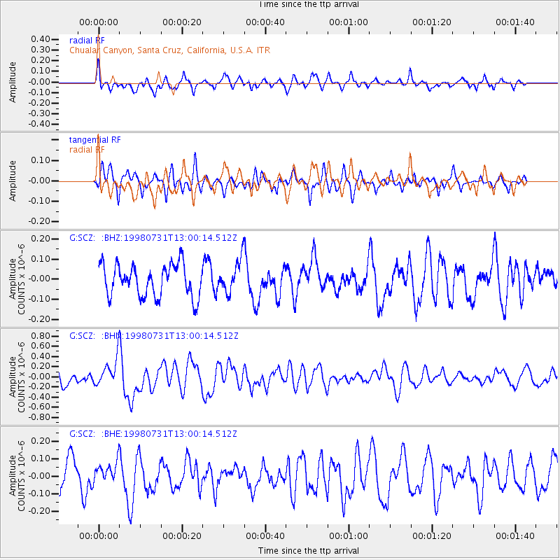
SCZ Chualar Canyon, Santa Cruz, California, U.S.A. - Earthquake Result Viewer
*The percent match for this event was below the threshold and hence no stack was calculated.
| Earthquake location: |
Southeast Of Loyalty Islands |
| Earthquake latitude/longitude: |
-21.6/169.9 |
| Earthquake time(UTC): |
1998/07/31 (212) 12:48:04 GMT |
| Earthquake Depth: |
33 km |
| Earthquake Magnitude: |
5.5 MB, 5.3 MS, 5.8 UNKNOWN |
| Earthquake Catalog/Contributor: |
WHDF/NEIC |
|
| Network: |
G GEOSCOPE |
| Station: |
SCZ Chualar Canyon, Santa Cruz, California, U.S.A. |
| Lat/Lon: |
36.60 N/121.40 W |
| Elevation: |
261 m |
|
| Distance: |
86.9 deg |
| Az: |
48.658 deg |
| Baz: |
240.221 deg |
| Ray Param: |
$rayparam |
*The percent match for this event was below the threshold and hence was not used in the summary stack. |
|
| Radial Match: |
61.741104 % |
| Radial Bump: |
400 |
| Transverse Match: |
56.01411 % |
| Transverse Bump: |
400 |
| SOD ConfigId: |
4480 |
| Insert Time: |
2010-02-26 23:54:19.321 +0000 |
| GWidth: |
2.5 |
| Max Bumps: |
400 |
| Tol: |
0.001 |
|
Signal To Noise
| Channel | StoN | STA | LTA |
| G:SCZ: :BHN:19980731T13:00:14.512Z | 1.7729927 | 2.8716238E-7 | 1.6196478E-7 |
| G:SCZ: :BHE:19980731T13:00:14.512Z | 0.69339913 | 5.8389602E-8 | 8.4207784E-8 |
| G:SCZ: :BHZ:19980731T13:00:14.512Z | 1.0664525 | 8.4662325E-8 | 7.938687E-8 |
| Arrivals |
| Ps | |
| PpPs | |
| PsPs/PpSs | |


