You are here: Home > Network List > G - GEOSCOPE Stations List
> Station SCZ Chualar Canyon, Santa Cruz, California, U.S.A. > Earthquake Result Viewer
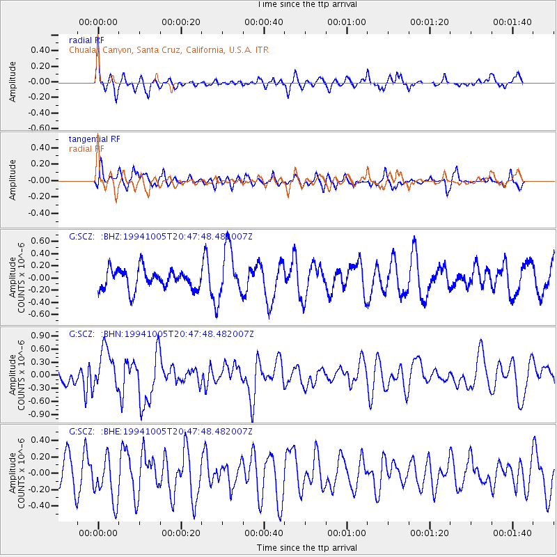
SCZ Chualar Canyon, Santa Cruz, California, U.S.A. - Earthquake Result Viewer
*The percent match for this event was below the threshold and hence no stack was calculated.
| Earthquake location: |
Kuril Islands |
| Earthquake latitude/longitude: |
43.5/147.5 |
| Earthquake time(UTC): |
1994/10/05 (278) 20:37:31 GMT |
| Earthquake Depth: |
33 km |
| Earthquake Magnitude: |
5.7 MB, 5.9 MS, 5.9 UNKNOWN, 5.9 MW |
| Earthquake Catalog/Contributor: |
WHDF/NEIC |
|
| Network: |
G GEOSCOPE |
| Station: |
SCZ Chualar Canyon, Santa Cruz, California, U.S.A. |
| Lat/Lon: |
36.60 N/121.40 W |
| Elevation: |
261 m |
|
| Distance: |
66.7 deg |
| Az: |
61.185 deg |
| Baz: |
307.654 deg |
| Ray Param: |
$rayparam |
*The percent match for this event was below the threshold and hence was not used in the summary stack. |
|
| Radial Match: |
58.201424 % |
| Radial Bump: |
388 |
| Transverse Match: |
48.860676 % |
| Transverse Bump: |
400 |
| SOD ConfigId: |
4480 |
| Insert Time: |
2010-02-26 23:54:22.100 +0000 |
| GWidth: |
2.5 |
| Max Bumps: |
400 |
| Tol: |
0.001 |
|
Signal To Noise
| Channel | StoN | STA | LTA |
| G:SCZ: :BHN:19941005T20:47:48.482007Z | 2.7479868 | 4.793954E-7 | 1.7445332E-7 |
| G:SCZ: :BHE:19941005T20:47:48.482007Z | 1.5983967 | 2.784148E-7 | 1.741838E-7 |
| G:SCZ: :BHZ:19941005T20:47:48.482007Z | 2.4649591 | 4.0168587E-7 | 1.6295843E-7 |
| Arrivals |
| Ps | |
| PpPs | |
| PsPs/PpSs | |


