You are here: Home > Network List > TA - USArray Transportable Network (new EarthScope stations) Stations List
> Station Q37A Longview Farm, Lee's Summit, MO, USA > Earthquake Result Viewer
Q37A Longview Farm, Lee's Summit, MO, USA - Earthquake Result Viewer
| Earthquake location: |
Salta Province, Argentina |
| Earthquake latitude/longitude: |
-22.1/-63.6 |
| Earthquake time(UTC): |
2012/06/02 (154) 07:52:53 GMT |
| Earthquake Depth: |
527 km |
| Earthquake Magnitude: |
5.8 MB, 5.9 MW, 6.0 MW |
| Earthquake Catalog/Contributor: |
WHDF/NEIC |
|
| Network: |
TA USArray Transportable Network (new EarthScope stations) |
| Station: |
Q37A Longview Farm, Lee's Summit, MO, USA |
| Lat/Lon: |
38.88 N/94.45 W |
| Elevation: |
297 m |
|
| Distance: |
67.2 deg |
| Az: |
334.223 deg |
| Baz: |
148.88 deg |
| Ray Param: |
0.05528969 |
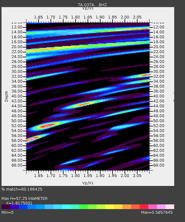
| Estimated Moho Depth: |
57.25 km |
| Estimated Crust Vp/Vs: |
1.62 |
| Assumed Crust Vp: |
6.498 km/s |
| Estimated Crust Vs: |
4.017 km/s |
| Estimated Crust Poisson's Ratio: |
0.19 |
|
| Radial Match: |
80.199425 % |
| Radial Bump: |
384 |
| Transverse Match: |
66.055885 % |
| Transverse Bump: |
400 |
| SOD ConfigId: |
455246 |
| Insert Time: |
2012-09-25 04:48:43.566 +0000 |
| GWidth: |
2.5 |
| Max Bumps: |
400 |
| Tol: |
0.001 |
|

Signal To Noise
| Channel | StoN | STA | LTA |
| TA:Q37A: :BHZ:20120602T08:02:24.450022Z | 28.019846 | 3.225502E-6 | 1.1511491E-7 |
| TA:Q37A: :BHN:20120602T08:02:24.450022Z | 8.966922 | 1.4233572E-6 | 1.5873421E-7 |
| TA:Q37A: :BHE:20120602T08:02:24.450022Z | 9.382013 | 9.3179847E-7 | 9.931754E-8 |
| Arrivals |
| Ps | 5.7 SECOND |
| PpPs | 22 SECOND |
| PsPs/PpSs | 28 SECOND |


