You are here: Home > Network List > TA - USArray Transportable Network (new EarthScope stations) Stations List
> Station I32A Karley and Nick, Howard, SD, USA > Earthquake Result Viewer
I32A Karley and Nick, Howard, SD, USA - Earthquake Result Viewer
| Earthquake location: |
Salta Province, Argentina |
| Earthquake latitude/longitude: |
-22.1/-63.6 |
| Earthquake time(UTC): |
2012/06/02 (154) 07:52:53 GMT |
| Earthquake Depth: |
527 km |
| Earthquake Magnitude: |
5.8 MB, 5.9 MW, 6.0 MW |
| Earthquake Catalog/Contributor: |
WHDF/NEIC |
|
| Network: |
TA USArray Transportable Network (new EarthScope stations) |
| Station: |
I32A Karley and Nick, Howard, SD, USA |
| Lat/Lon: |
44.03 N/97.46 W |
| Elevation: |
493 m |
|
| Distance: |
72.7 deg |
| Az: |
335.077 deg |
| Baz: |
147.184 deg |
| Ray Param: |
0.051759 |
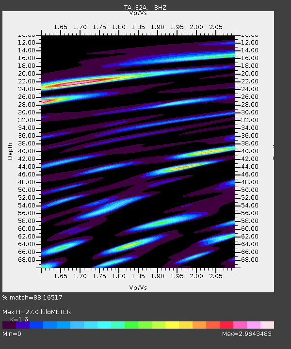
| Estimated Moho Depth: |
27.0 km |
| Estimated Crust Vp/Vs: |
1.60 |
| Assumed Crust Vp: |
6.552 km/s |
| Estimated Crust Vs: |
4.095 km/s |
| Estimated Crust Poisson's Ratio: |
0.18 |
|
| Radial Match: |
88.16517 % |
| Radial Bump: |
391 |
| Transverse Match: |
82.92762 % |
| Transverse Bump: |
368 |
| SOD ConfigId: |
455246 |
| Insert Time: |
2012-09-25 04:48:56.229 +0000 |
| GWidth: |
2.5 |
| Max Bumps: |
400 |
| Tol: |
0.001 |
|
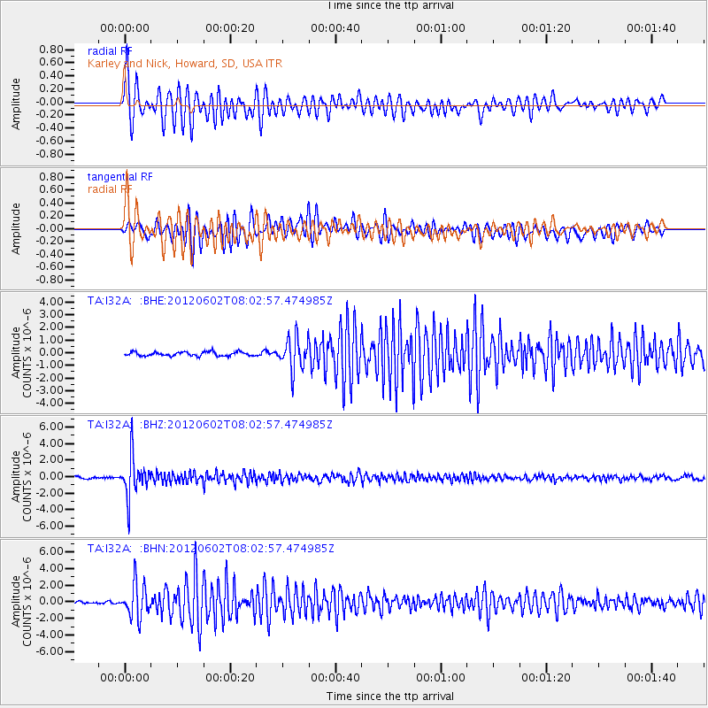
Signal To Noise
| Channel | StoN | STA | LTA |
| TA:I32A: :BHZ:20120602T08:02:57.474985Z | 15.057873 | 2.4447604E-6 | 1.6235761E-7 |
| TA:I32A: :BHN:20120602T08:02:57.474985Z | 14.262473 | 2.0253613E-6 | 1.4200631E-7 |
| TA:I32A: :BHE:20120602T08:02:57.474985Z | 7.9461637 | 1.2646292E-6 | 1.5914965E-7 |
| Arrivals |
| Ps | 2.6 SECOND |
| PpPs | 10 SECOND |
| PsPs/PpSs | 13 SECOND |


