You are here: Home > Network List > TA - USArray Transportable Network (new EarthScope stations) Stations List
> Station D31A Mcclaflin, Tower City, ND, USA > Earthquake Result Viewer
D31A Mcclaflin, Tower City, ND, USA - Earthquake Result Viewer

| Earthquake location: |
Salta Province, Argentina |
| Earthquake latitude/longitude: |
-22.1/-63.6 |
| Earthquake time(UTC): |
2012/06/02 (154) 07:52:53 GMT |
| Earthquake Depth: |
527 km |
| Earthquake Magnitude: |
5.8 MB, 5.9 MW, 6.0 MW |
| Earthquake Catalog/Contributor: |
WHDF/NEIC |
|
| Network: |
TA USArray Transportable Network (new EarthScope stations) |
| Station: |
D31A Mcclaflin, Tower City, ND, USA |
| Lat/Lon: |
47.05 N/97.72 W |
| Elevation: |
359 m |
|
| Distance: |
75.4 deg |
| Az: |
336.615 deg |
| Baz: |
147.423 deg |
| Ray Param: |
0.050050374 |
| Estimated Moho Depth: |
20.25 km |
| Estimated Crust Vp/Vs: |
1.76 |
| Assumed Crust Vp: |
6.498 km/s |
| Estimated Crust Vs: |
3.692 km/s |
| Estimated Crust Poisson's Ratio: |
0.26 |
|
| Radial Match: |
87.992424 % |
| Radial Bump: |
400 |
| Transverse Match: |
71.842735 % |
| Transverse Bump: |
400 |
| SOD ConfigId: |
455246 |
| Insert Time: |
2012-09-25 04:49:47.938 +0000 |
| GWidth: |
2.5 |
| Max Bumps: |
400 |
| Tol: |
0.001 |
|
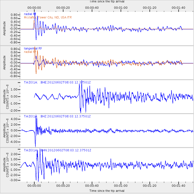
Signal To Noise
| Channel | StoN | STA | LTA |
| TA:D31A: :BHZ:20120602T08:03:12.37501Z | 7.505682 | 1.9014092E-6 | 2.5332932E-7 |
| TA:D31A: :BHN:20120602T08:03:12.37501Z | 6.247474 | 1.519517E-6 | 2.4322102E-7 |
| TA:D31A: :BHE:20120602T08:03:12.37501Z | 4.857769 | 1.0862484E-6 | 2.2361057E-7 |
| Arrivals |
| Ps | 2.4 SECOND |
| PpPs | 8.3 SECOND |
| PsPs/PpSs | 11 SECOND |


