You are here: Home > Network List > G - GEOSCOPE Stations List
> Station SCZ Chualar Canyon, Santa Cruz, California, U.S.A. > Earthquake Result Viewer
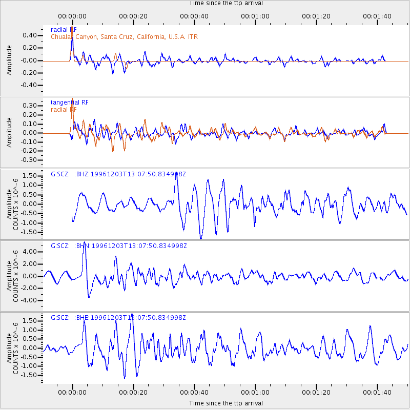
SCZ Chualar Canyon, Santa Cruz, California, U.S.A. - Earthquake Result Viewer
*The percent match for this event was below the threshold and hence no stack was calculated.
| Earthquake location: |
Tonga Islands Region |
| Earthquake latitude/longitude: |
-18.4/-172.3 |
| Earthquake time(UTC): |
1996/12/03 (338) 12:56:56 GMT |
| Earthquake Depth: |
33 km |
| Earthquake Magnitude: |
6.0 MB, 6.0 MS, 6.1 UNKNOWN, 6.1 MW |
| Earthquake Catalog/Contributor: |
WHDF/NEIC |
|
| Network: |
G GEOSCOPE |
| Station: |
SCZ Chualar Canyon, Santa Cruz, California, U.S.A. |
| Lat/Lon: |
36.60 N/121.40 W |
| Elevation: |
261 m |
|
| Distance: |
72.7 deg |
| Az: |
40.82 deg |
| Baz: |
230.487 deg |
| Ray Param: |
$rayparam |
*The percent match for this event was below the threshold and hence was not used in the summary stack. |
|
| Radial Match: |
72.40058 % |
| Radial Bump: |
280 |
| Transverse Match: |
69.40138 % |
| Transverse Bump: |
400 |
| SOD ConfigId: |
4480 |
| Insert Time: |
2010-02-26 23:54:25.491 +0000 |
| GWidth: |
2.5 |
| Max Bumps: |
400 |
| Tol: |
0.001 |
|
Signal To Noise
| Channel | StoN | STA | LTA |
| G:SCZ: :BHN:19961203T13:07:50.834998Z | 3.5701048 | 2.1779565E-6 | 6.100539E-7 |
| G:SCZ: :BHE:19961203T13:07:50.834998Z | 3.4567277 | 5.66436E-7 | 1.638648E-7 |
| G:SCZ: :BHZ:19961203T13:07:50.834998Z | 1.9973847 | 6.7942267E-7 | 3.4015616E-7 |
| Arrivals |
| Ps | |
| PpPs | |
| PsPs/PpSs | |


