You are here: Home > Network List > TX - Texas Seismological Network Stations List
> Station PB01 Permian Basin 1 > Earthquake Result Viewer
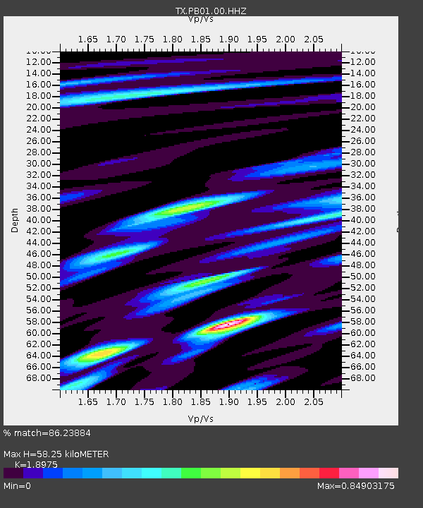
PB01 Permian Basin 1 - Earthquake Result Viewer
| Earthquake location: |
East Of Kuril Islands |
| Earthquake latitude/longitude: |
50.5/160.0 |
| Earthquake time(UTC): |
2019/03/28 (087) 22:06:49 GMT |
| Earthquake Depth: |
9.0 km |
| Earthquake Magnitude: |
6.2 Mww |
| Earthquake Catalog/Contributor: |
NEIC PDE/us |
|
| Network: |
TX Texas Seismological Network |
| Station: |
PB01 Permian Basin 1 |
| Lat/Lon: |
30.94 N/103.78 W |
| Elevation: |
1010 m |
|
| Distance: |
70.5 deg |
| Az: |
64.971 deg |
| Baz: |
317.666 deg |
| Ray Param: |
0.054950036 |
| Estimated Moho Depth: |
58.25 km |
| Estimated Crust Vp/Vs: |
1.90 |
| Assumed Crust Vp: |
6.121 km/s |
| Estimated Crust Vs: |
3.226 km/s |
| Estimated Crust Poisson's Ratio: |
0.31 |
|
| Radial Match: |
86.23884 % |
| Radial Bump: |
400 |
| Transverse Match: |
67.46991 % |
| Transverse Bump: |
400 |
| SOD ConfigId: |
3426611 |
| Insert Time: |
2019-04-11 22:25:20.694 +0000 |
| GWidth: |
2.5 |
| Max Bumps: |
400 |
| Tol: |
0.001 |
|

Signal To Noise
| Channel | StoN | STA | LTA |
| TX:PB01:00:HHZ:20190328T22:17:32.999976Z | 12.611668 | 2.160467E-6 | 1.71307E-7 |
| TX:PB01:00:HH1:20190328T22:17:32.999976Z | 7.163986 | 5.2027474E-7 | 7.2623635E-8 |
| TX:PB01:00:HH2:20190328T22:17:32.999976Z | 7.1057935 | 9.136622E-7 | 1.285799E-7 |
| Arrivals |
| Ps | 8.8 SECOND |
| PpPs | 27 SECOND |
| PsPs/PpSs | 36 SECOND |


