You are here: Home > Network List > TA - USArray Transportable Network (new EarthScope stations) Stations List
> Station V41A Mountainview, AR, USA > Earthquake Result Viewer
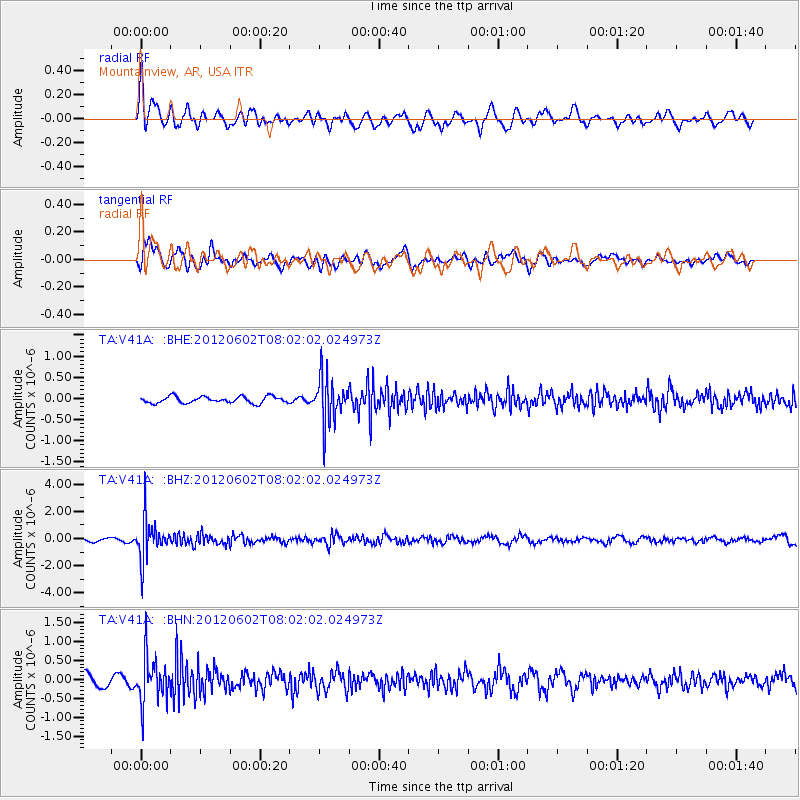
V41A Mountainview, AR, USA - Earthquake Result Viewer
*The percent match for this event was below the threshold and hence no stack was calculated.
| Earthquake location: |
Salta Province, Argentina |
| Earthquake latitude/longitude: |
-22.1/-63.6 |
| Earthquake time(UTC): |
2012/06/02 (154) 07:52:53 GMT |
| Earthquake Depth: |
527 km |
| Earthquake Magnitude: |
5.8 MB, 5.9 MW, 6.0 MW |
| Earthquake Catalog/Contributor: |
WHDF/NEIC |
|
| Network: |
TA USArray Transportable Network (new EarthScope stations) |
| Station: |
V41A Mountainview, AR, USA |
| Lat/Lon: |
35.79 N/92.16 W |
| Elevation: |
413 m |
|
| Distance: |
63.6 deg |
| Az: |
334.241 deg |
| Baz: |
150.275 deg |
| Ray Param: |
$rayparam |
*The percent match for this event was below the threshold and hence was not used in the summary stack. |
|
| Radial Match: |
72.97877 % |
| Radial Bump: |
400 |
| Transverse Match: |
72.04593 % |
| Transverse Bump: |
400 |
| SOD ConfigId: |
455246 |
| Insert Time: |
2012-09-25 05:04:23.073 +0000 |
| GWidth: |
2.5 |
| Max Bumps: |
400 |
| Tol: |
0.001 |
|
Signal To Noise
| Channel | StoN | STA | LTA |
| TA:V41A: :BHZ:20120602T08:02:02.024973Z | 8.808732 | 1.4679466E-6 | 1.6664674E-7 |
| TA:V41A: :BHN:20120602T08:02:02.024973Z | 4.035847 | 6.032406E-7 | 1.4947064E-7 |
| TA:V41A: :BHE:20120602T08:02:02.024973Z | 6.967726 | 5.316847E-7 | 7.630677E-8 |
| Arrivals |
| Ps | |
| PpPs | |
| PsPs/PpSs | |


