You are here: Home > Network List > TA - USArray Transportable Network (new EarthScope stations) Stations List
> Station L39A Vinton, IA, USA > Earthquake Result Viewer
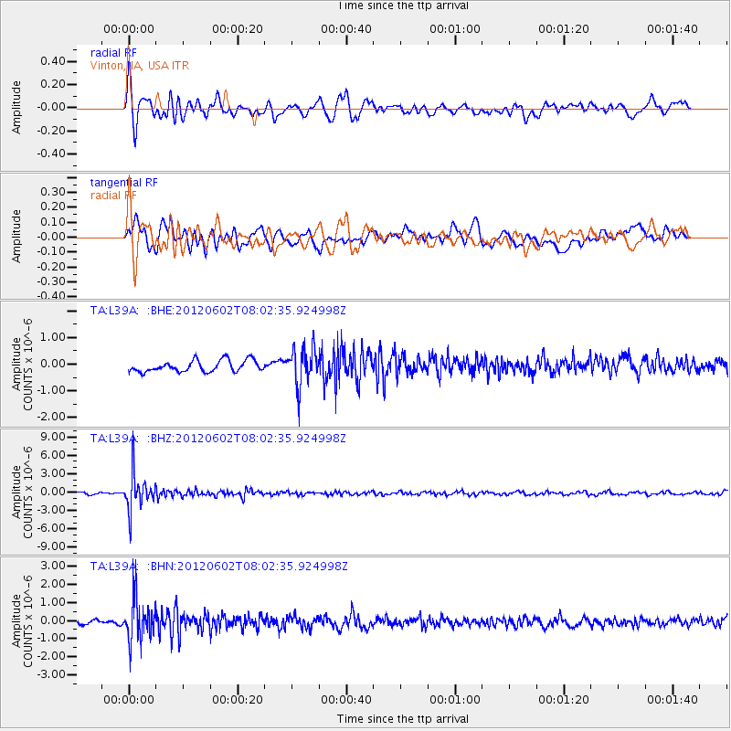
L39A Vinton, IA, USA - Earthquake Result Viewer
*The percent match for this event was below the threshold and hence no stack was calculated.
| Earthquake location: |
Salta Province, Argentina |
| Earthquake latitude/longitude: |
-22.1/-63.6 |
| Earthquake time(UTC): |
2012/06/02 (154) 07:52:53 GMT |
| Earthquake Depth: |
527 km |
| Earthquake Magnitude: |
5.8 MB, 5.9 MW, 6.0 MW |
| Earthquake Catalog/Contributor: |
WHDF/NEIC |
|
| Network: |
TA USArray Transportable Network (new EarthScope stations) |
| Station: |
L39A Vinton, IA, USA |
| Lat/Lon: |
42.12 N/92.00 W |
| Elevation: |
261 m |
|
| Distance: |
69.1 deg |
| Az: |
337.704 deg |
| Baz: |
151.764 deg |
| Ray Param: |
$rayparam |
*The percent match for this event was below the threshold and hence was not used in the summary stack. |
|
| Radial Match: |
73.68105 % |
| Radial Bump: |
400 |
| Transverse Match: |
68.448944 % |
| Transverse Bump: |
400 |
| SOD ConfigId: |
455246 |
| Insert Time: |
2012-09-25 05:06:05.545 +0000 |
| GWidth: |
2.5 |
| Max Bumps: |
400 |
| Tol: |
0.001 |
|
Signal To Noise
| Channel | StoN | STA | LTA |
| TA:L39A: :BHZ:20120602T08:02:35.924998Z | 16.735367 | 2.9285027E-6 | 1.7498886E-7 |
| TA:L39A: :BHN:20120602T08:02:35.924998Z | 6.7035303 | 1.1516839E-6 | 1.718026E-7 |
| TA:L39A: :BHE:20120602T08:02:35.924998Z | 3.320713 | 7.009419E-7 | 2.1108174E-7 |
| Arrivals |
| Ps | |
| PpPs | |
| PsPs/PpSs | |


