You are here: Home > Network List > TA - USArray Transportable Network (new EarthScope stations) Stations List
> Station M39A Webster, IA, USA > Earthquake Result Viewer
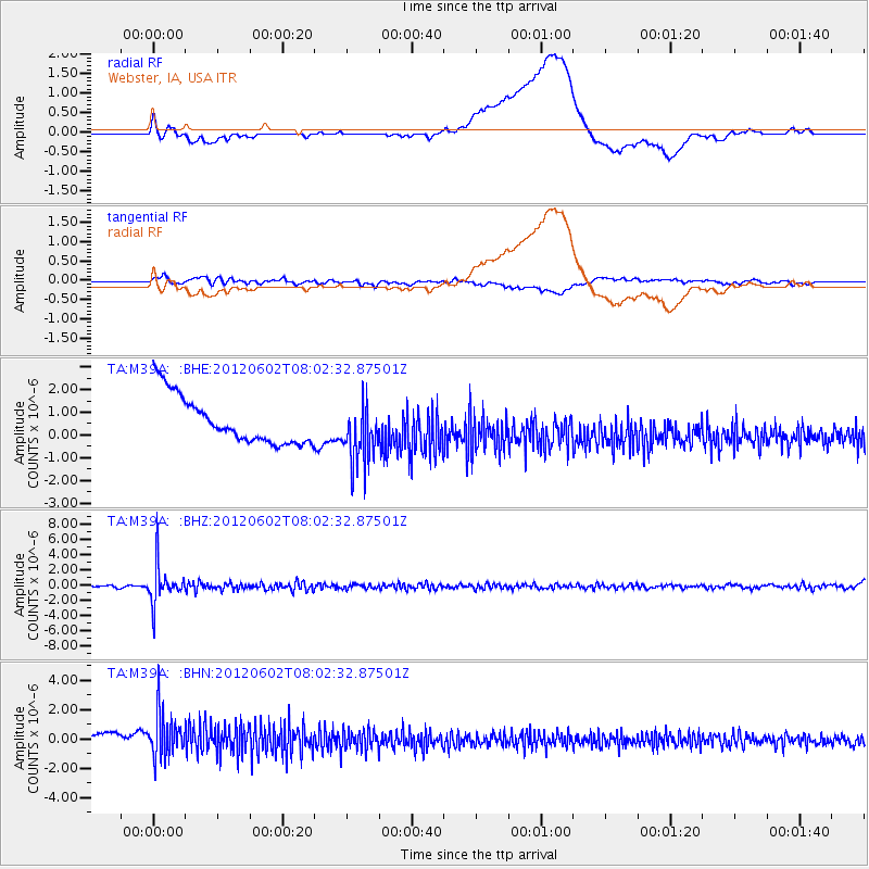
M39A Webster, IA, USA - Earthquake Result Viewer
*The percent match for this event was below the threshold and hence no stack was calculated.
| Earthquake location: |
Salta Province, Argentina |
| Earthquake latitude/longitude: |
-22.1/-63.6 |
| Earthquake time(UTC): |
2012/06/02 (154) 07:52:53 GMT |
| Earthquake Depth: |
527 km |
| Earthquake Magnitude: |
5.8 MB, 5.9 MW, 6.0 MW |
| Earthquake Catalog/Contributor: |
WHDF/NEIC |
|
| Network: |
TA USArray Transportable Network (new EarthScope stations) |
| Station: |
M39A Webster, IA, USA |
| Lat/Lon: |
41.48 N/92.17 W |
| Elevation: |
264 m |
|
| Distance: |
68.6 deg |
| Az: |
337.254 deg |
| Baz: |
151.488 deg |
| Ray Param: |
$rayparam |
*The percent match for this event was below the threshold and hence was not used in the summary stack. |
|
| Radial Match: |
37.430435 % |
| Radial Bump: |
400 |
| Transverse Match: |
55.84783 % |
| Transverse Bump: |
400 |
| SOD ConfigId: |
455246 |
| Insert Time: |
2012-09-25 05:06:19.462 +0000 |
| GWidth: |
2.5 |
| Max Bumps: |
400 |
| Tol: |
0.001 |
|
Signal To Noise
| Channel | StoN | STA | LTA |
| TA:M39A: :BHZ:20120602T08:02:32.87501Z | 22.39361 | 2.4929443E-6 | 1.11323914E-7 |
| TA:M39A: :BHN:20120602T08:02:32.87501Z | 1.3230006 | 1.8228368E-6 | 1.377805E-6 |
| TA:M39A: :BHE:20120602T08:02:32.87501Z | 1.2938443 | 1.3488753E-6 | 1.0425329E-6 |
| Arrivals |
| Ps | |
| PpPs | |
| PsPs/PpSs | |


