You are here: Home > Network List > TA - USArray Transportable Network (new EarthScope stations) Stations List
> Station S41A Jillco Farms, Salem, MO, USA > Earthquake Result Viewer
S41A Jillco Farms, Salem, MO, USA - Earthquake Result Viewer
| Earthquake location: |
Salta Province, Argentina |
| Earthquake latitude/longitude: |
-22.1/-63.6 |
| Earthquake time(UTC): |
2012/06/02 (154) 07:52:53 GMT |
| Earthquake Depth: |
527 km |
| Earthquake Magnitude: |
5.8 MB, 5.9 MW, 6.0 MW |
| Earthquake Catalog/Contributor: |
WHDF/NEIC |
|
| Network: |
TA USArray Transportable Network (new EarthScope stations) |
| Station: |
S41A Jillco Farms, Salem, MO, USA |
| Lat/Lon: |
37.59 N/91.75 W |
| Elevation: |
376 m |
|
| Distance: |
65.0 deg |
| Az: |
335.538 deg |
| Baz: |
151.081 deg |
| Ray Param: |
0.056661308 |
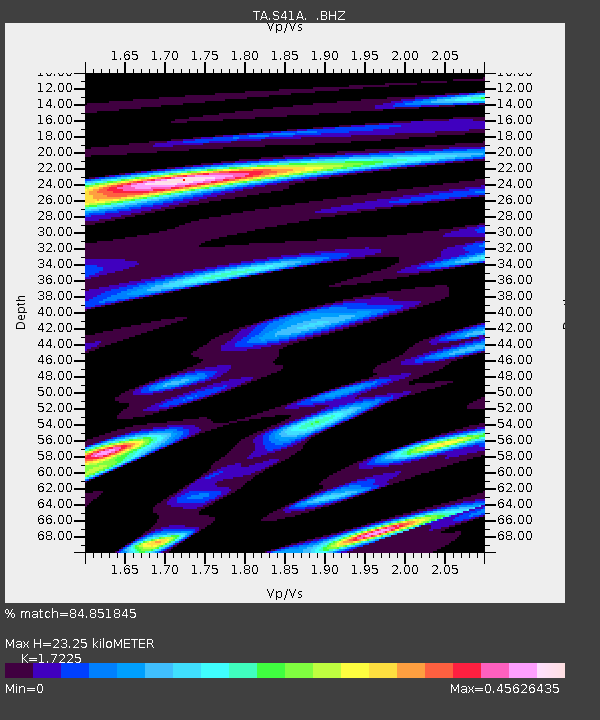
| Estimated Moho Depth: |
23.25 km |
| Estimated Crust Vp/Vs: |
1.72 |
| Assumed Crust Vp: |
6.53 km/s |
| Estimated Crust Vs: |
3.791 km/s |
| Estimated Crust Poisson's Ratio: |
0.25 |
|
| Radial Match: |
84.851845 % |
| Radial Bump: |
318 |
| Transverse Match: |
75.26822 % |
| Transverse Bump: |
388 |
| SOD ConfigId: |
455246 |
| Insert Time: |
2012-09-25 05:06:30.835 +0000 |
| GWidth: |
2.5 |
| Max Bumps: |
400 |
| Tol: |
0.001 |
|
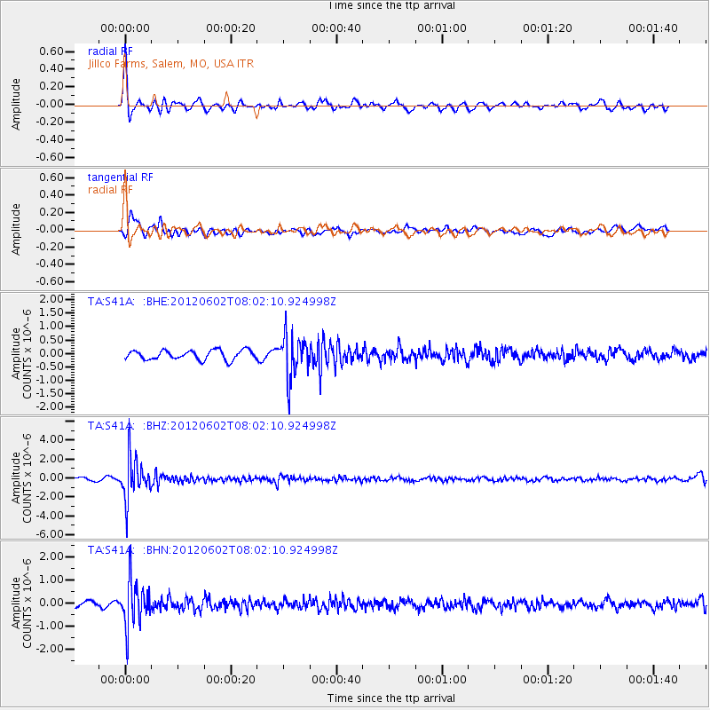
Signal To Noise
| Channel | StoN | STA | LTA |
| TA:S41A: :BHZ:20120602T08:02:10.924998Z | 12.003006 | 2.1656374E-6 | 1.8042459E-7 |
| TA:S41A: :BHN:20120602T08:02:10.924998Z | 7.876266 | 1.0078477E-6 | 1.2796009E-7 |
| TA:S41A: :BHE:20120602T08:02:10.924998Z | 4.472512 | 7.7831277E-7 | 1.7402141E-7 |
| Arrivals |
| Ps | 2.7 SECOND |
| PpPs | 9.3 SECOND |
| PsPs/PpSs | 12 SECOND |


