You are here: Home > Network List > TA - USArray Transportable Network (new EarthScope stations) Stations List
> Station L40A Anamosa, IA, USA > Earthquake Result Viewer
L40A Anamosa, IA, USA - Earthquake Result Viewer
| Earthquake location: |
Salta Province, Argentina |
| Earthquake latitude/longitude: |
-22.1/-63.6 |
| Earthquake time(UTC): |
2012/06/02 (154) 07:52:53 GMT |
| Earthquake Depth: |
527 km |
| Earthquake Magnitude: |
5.8 MB, 5.9 MW, 6.0 MW |
| Earthquake Catalog/Contributor: |
WHDF/NEIC |
|
| Network: |
TA USArray Transportable Network (new EarthScope stations) |
| Station: |
L40A Anamosa, IA, USA |
| Lat/Lon: |
42.06 N/91.22 W |
| Elevation: |
242 m |
|
| Distance: |
68.7 deg |
| Az: |
338.222 deg |
| Baz: |
152.471 deg |
| Ray Param: |
0.05430267 |
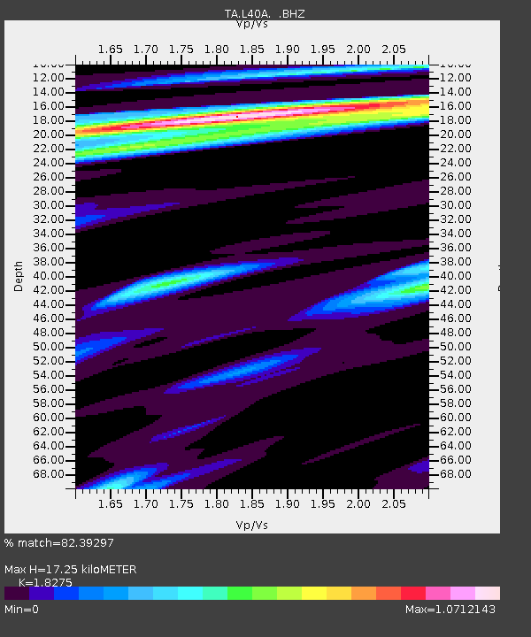
| Estimated Moho Depth: |
17.25 km |
| Estimated Crust Vp/Vs: |
1.83 |
| Assumed Crust Vp: |
6.53 km/s |
| Estimated Crust Vs: |
3.573 km/s |
| Estimated Crust Poisson's Ratio: |
0.29 |
|
| Radial Match: |
82.39297 % |
| Radial Bump: |
400 |
| Transverse Match: |
75.25141 % |
| Transverse Bump: |
400 |
| SOD ConfigId: |
455246 |
| Insert Time: |
2012-09-25 05:06:43.630 +0000 |
| GWidth: |
2.5 |
| Max Bumps: |
400 |
| Tol: |
0.001 |
|
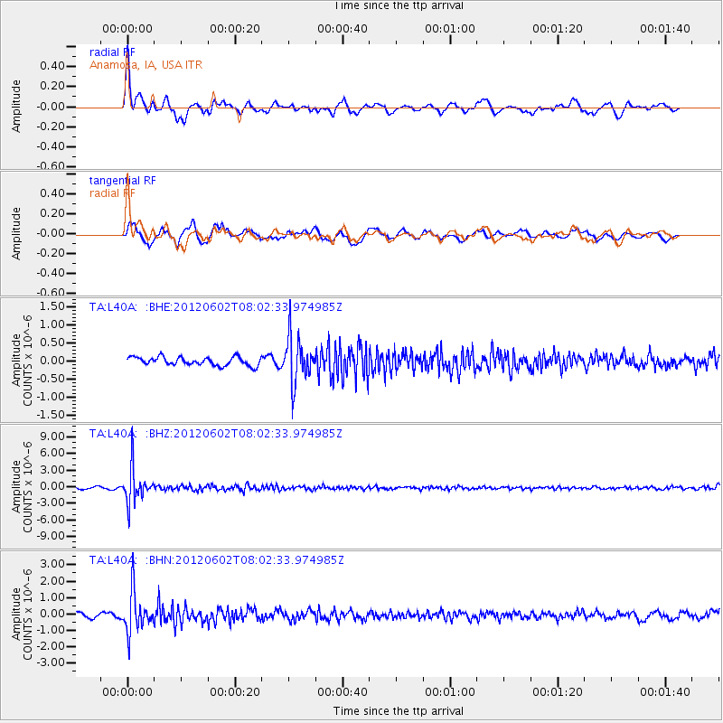
Signal To Noise
| Channel | StoN | STA | LTA |
| TA:L40A: :BHZ:20120602T08:02:33.974985Z | 18.934269 | 3.0980145E-6 | 1.6361945E-7 |
| TA:L40A: :BHN:20120602T08:02:33.974985Z | 9.160922 | 1.211608E-6 | 1.3225831E-7 |
| TA:L40A: :BHE:20120602T08:02:33.974985Z | 5.439899 | 6.237554E-7 | 1.14663045E-7 |
| Arrivals |
| Ps | 2.3 SECOND |
| PpPs | 7.2 SECOND |
| PsPs/PpSs | 9.5 SECOND |


