You are here: Home > Network List > TA - USArray Transportable Network (new EarthScope stations) Stations List
> Station U43A Rector, AR, USA > Earthquake Result Viewer
U43A Rector, AR, USA - Earthquake Result Viewer
| Earthquake location: |
Salta Province, Argentina |
| Earthquake latitude/longitude: |
-22.1/-63.6 |
| Earthquake time(UTC): |
2012/06/02 (154) 07:52:53 GMT |
| Earthquake Depth: |
527 km |
| Earthquake Magnitude: |
5.8 MB, 5.9 MW, 6.0 MW |
| Earthquake Catalog/Contributor: |
WHDF/NEIC |
|
| Network: |
TA USArray Transportable Network (new EarthScope stations) |
| Station: |
U43A Rector, AR, USA |
| Lat/Lon: |
36.37 N/90.41 W |
| Elevation: |
96 m |
|
| Distance: |
63.4 deg |
| Az: |
335.943 deg |
| Baz: |
152.06 deg |
| Ray Param: |
0.05765363 |
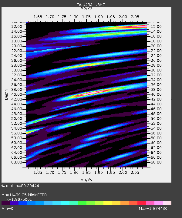
| Estimated Moho Depth: |
39.25 km |
| Estimated Crust Vp/Vs: |
1.87 |
| Assumed Crust Vp: |
6.53 km/s |
| Estimated Crust Vs: |
3.497 km/s |
| Estimated Crust Poisson's Ratio: |
0.30 |
|
| Radial Match: |
89.30444 % |
| Radial Bump: |
400 |
| Transverse Match: |
82.2674 % |
| Transverse Bump: |
400 |
| SOD ConfigId: |
455246 |
| Insert Time: |
2012-09-25 05:07:49.233 +0000 |
| GWidth: |
2.5 |
| Max Bumps: |
400 |
| Tol: |
0.001 |
|

Signal To Noise
| Channel | StoN | STA | LTA |
| TA:U43A: :BHZ:20120602T08:02:00.924998Z | 28.281961 | 2.862692E-6 | 1.0121971E-7 |
| TA:U43A: :BHN:20120602T08:02:00.924998Z | 13.559239 | 1.8583189E-6 | 1.3705186E-7 |
| TA:U43A: :BHE:20120602T08:02:00.924998Z | 12.330533 | 1.7720165E-6 | 1.4370964E-7 |
| Arrivals |
| Ps | 5.4 SECOND |
| PpPs | 17 SECOND |
| PsPs/PpSs | 22 SECOND |


