You are here: Home > Network List > TX - Texas Seismological Network Stations List
> Station SNAG San Augustine > Earthquake Result Viewer
SNAG San Augustine - Earthquake Result Viewer
| Earthquake location: |
East Of Kuril Islands |
| Earthquake latitude/longitude: |
50.5/160.0 |
| Earthquake time(UTC): |
2019/03/28 (087) 22:06:49 GMT |
| Earthquake Depth: |
9.0 km |
| Earthquake Magnitude: |
6.2 Mww |
| Earthquake Catalog/Contributor: |
NEIC PDE/us |
|
| Network: |
TX Texas Seismological Network |
| Station: |
SNAG San Augustine |
| Lat/Lon: |
31.52 N/94.18 W |
| Elevation: |
84 m |
|
| Distance: |
75.4 deg |
| Az: |
58.078 deg |
| Baz: |
320.606 deg |
| Ray Param: |
0.051666286 |
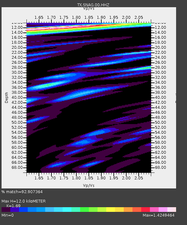
| Estimated Moho Depth: |
12.0 km |
| Estimated Crust Vp/Vs: |
1.69 |
| Assumed Crust Vp: |
5.738 km/s |
| Estimated Crust Vs: |
3.396 km/s |
| Estimated Crust Poisson's Ratio: |
0.23 |
|
| Radial Match: |
92.907364 % |
| Radial Bump: |
400 |
| Transverse Match: |
79.06996 % |
| Transverse Bump: |
400 |
| SOD ConfigId: |
3426611 |
| Insert Time: |
2019-04-11 22:25:56.430 +0000 |
| GWidth: |
2.5 |
| Max Bumps: |
400 |
| Tol: |
0.001 |
|
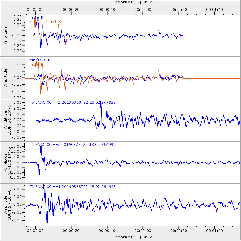
Signal To Noise
| Channel | StoN | STA | LTA |
| TX:SNAG:00:HHZ:20190328T22:18:02.26499Z | 34.961792 | 6.7087362E-6 | 1.9188765E-7 |
| TX:SNAG:00:HH1:20190328T22:18:02.26499Z | 8.818349 | 1.6295954E-6 | 1.8479598E-7 |
| TX:SNAG:00:HH2:20190328T22:18:02.26499Z | 3.361008 | 5.5464915E-7 | 1.6502466E-7 |
| Arrivals |
| Ps | 1.5 SECOND |
| PpPs | 5.5 SECOND |
| PsPs/PpSs | 7.0 SECOND |


