You are here: Home > Network List > TX - Texas Seismological Network Stations List
> Station VHRN Van Horn > Earthquake Result Viewer
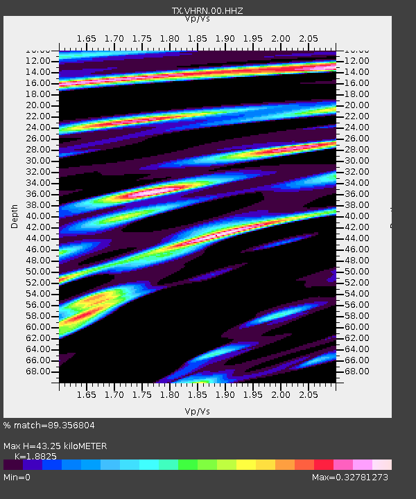
VHRN Van Horn - Earthquake Result Viewer
| Earthquake location: |
East Of Kuril Islands |
| Earthquake latitude/longitude: |
50.5/160.0 |
| Earthquake time(UTC): |
2019/03/28 (087) 22:06:49 GMT |
| Earthquake Depth: |
9.0 km |
| Earthquake Magnitude: |
6.2 Mww |
| Earthquake Catalog/Contributor: |
NEIC PDE/us |
|
| Network: |
TX Texas Seismological Network |
| Station: |
VHRN Van Horn |
| Lat/Lon: |
30.79 N/104.99 W |
| Elevation: |
1342 m |
|
| Distance: |
69.9 deg |
| Az: |
65.895 deg |
| Baz: |
317.364 deg |
| Ray Param: |
0.05533718 |
| Estimated Moho Depth: |
43.25 km |
| Estimated Crust Vp/Vs: |
1.88 |
| Assumed Crust Vp: |
6.361 km/s |
| Estimated Crust Vs: |
3.379 km/s |
| Estimated Crust Poisson's Ratio: |
0.30 |
|
| Radial Match: |
89.356804 % |
| Radial Bump: |
333 |
| Transverse Match: |
76.98169 % |
| Transverse Bump: |
400 |
| SOD ConfigId: |
3426611 |
| Insert Time: |
2019-04-11 22:25:59.168 +0000 |
| GWidth: |
2.5 |
| Max Bumps: |
400 |
| Tol: |
0.001 |
|

Signal To Noise
| Channel | StoN | STA | LTA |
| TX:VHRN:00:HHZ:20190328T22:17:29.42002Z | 12.416624 | 2.5816043E-6 | 2.0791516E-7 |
| TX:VHRN:00:HH1:20190328T22:17:29.42002Z | 8.218587 | 7.697213E-7 | 9.3656155E-8 |
| TX:VHRN:00:HH2:20190328T22:17:29.42002Z | 3.0877287 | 6.057744E-7 | 1.961877E-7 |
| Arrivals |
| Ps | 6.2 SECOND |
| PpPs | 19 SECOND |
| PsPs/PpSs | 25 SECOND |


