You are here: Home > Network List > TX - Texas Seismological Network Stations List
> Station WTFS Witchita Falls > Earthquake Result Viewer
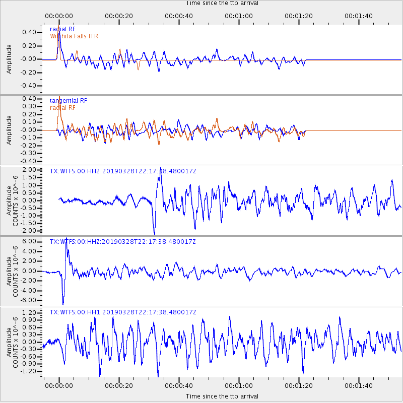
WTFS Witchita Falls - Earthquake Result Viewer
*The percent match for this event was below the threshold and hence no stack was calculated.
| Earthquake location: |
East Of Kuril Islands |
| Earthquake latitude/longitude: |
50.5/160.0 |
| Earthquake time(UTC): |
2019/03/28 (087) 22:06:49 GMT |
| Earthquake Depth: |
9.0 km |
| Earthquake Magnitude: |
6.2 Mww |
| Earthquake Catalog/Contributor: |
NEIC PDE/us |
|
| Network: |
TX Texas Seismological Network |
| Station: |
WTFS Witchita Falls |
| Lat/Lon: |
33.77 N/98.46 W |
| Elevation: |
277 m |
|
| Distance: |
71.4 deg |
| Az: |
59.439 deg |
| Baz: |
318.692 deg |
| Ray Param: |
$rayparam |
*The percent match for this event was below the threshold and hence was not used in the summary stack. |
|
| Radial Match: |
79.17723 % |
| Radial Bump: |
400 |
| Transverse Match: |
81.487206 % |
| Transverse Bump: |
400 |
| SOD ConfigId: |
3426611 |
| Insert Time: |
2019-04-11 22:25:59.843 +0000 |
| GWidth: |
2.5 |
| Max Bumps: |
400 |
| Tol: |
0.001 |
|
Signal To Noise
| Channel | StoN | STA | LTA |
| TX:WTFS:00:HHZ:20190328T22:17:38.480017Z | 25.854158 | 3.0416497E-6 | 1.1764644E-7 |
| TX:WTFS:00:HH1:20190328T22:17:38.480017Z | 2.9054818 | 4.2689737E-7 | 1.4692826E-7 |
| TX:WTFS:00:HH2:20190328T22:17:38.480017Z | 7.3640532 | 1.1245498E-6 | 1.5270801E-7 |
| Arrivals |
| Ps | |
| PpPs | |
| PsPs/PpSs | |


