You are here: Home > Network List > TA - USArray Transportable Network (new EarthScope stations) Stations List
> Station D41A Chassel, MI, USA > Earthquake Result Viewer
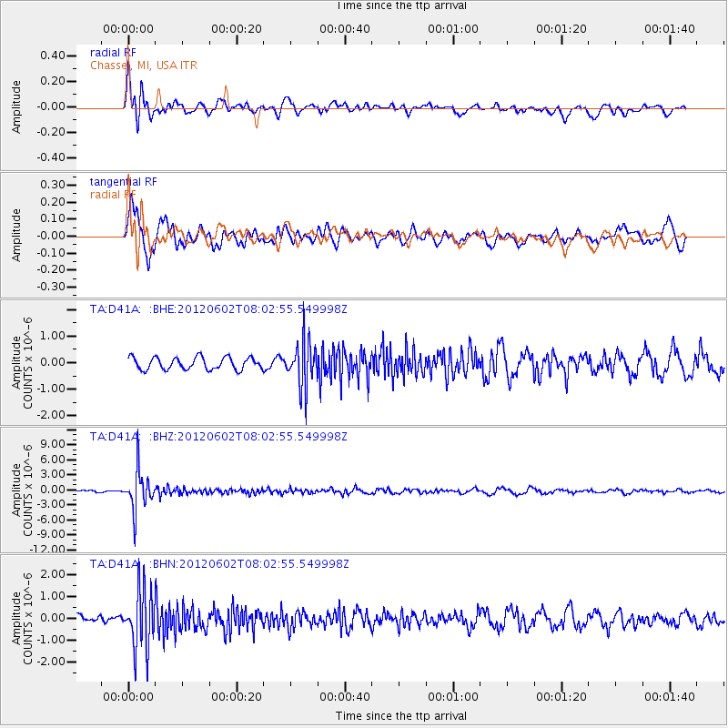
D41A Chassel, MI, USA - Earthquake Result Viewer
*The percent match for this event was below the threshold and hence no stack was calculated.
| Earthquake location: |
Salta Province, Argentina |
| Earthquake latitude/longitude: |
-22.1/-63.6 |
| Earthquake time(UTC): |
2012/06/02 (154) 07:52:53 GMT |
| Earthquake Depth: |
527 km |
| Earthquake Magnitude: |
5.8 MB, 5.9 MW, 6.0 MW |
| Earthquake Catalog/Contributor: |
WHDF/NEIC |
|
| Network: |
TA USArray Transportable Network (new EarthScope stations) |
| Station: |
D41A Chassel, MI, USA |
| Lat/Lon: |
47.06 N/88.57 W |
| Elevation: |
271 m |
|
| Distance: |
72.4 deg |
| Az: |
342.348 deg |
| Baz: |
155.704 deg |
| Ray Param: |
$rayparam |
*The percent match for this event was below the threshold and hence was not used in the summary stack. |
|
| Radial Match: |
73.71399 % |
| Radial Bump: |
400 |
| Transverse Match: |
70.12781 % |
| Transverse Bump: |
400 |
| SOD ConfigId: |
455246 |
| Insert Time: |
2012-09-25 05:11:15.451 +0000 |
| GWidth: |
2.5 |
| Max Bumps: |
400 |
| Tol: |
0.001 |
|
Signal To Noise
| Channel | StoN | STA | LTA |
| TA:D41A: :BHZ:20120602T08:02:55.549998Z | 19.178015 | 3.927051E-6 | 2.0476837E-7 |
| TA:D41A: :BHN:20120602T08:02:55.549998Z | 7.0013394 | 1.3578042E-6 | 1.9393492E-7 |
| TA:D41A: :BHE:20120602T08:02:55.549998Z | 3.758405 | 8.6065705E-7 | 2.2899529E-7 |
| Arrivals |
| Ps | |
| PpPs | |
| PsPs/PpSs | |


