You are here: Home > Network List > TA - USArray Transportable Network (new EarthScope stations) Stations List
> Station G43A Wallace, MI, USA > Earthquake Result Viewer
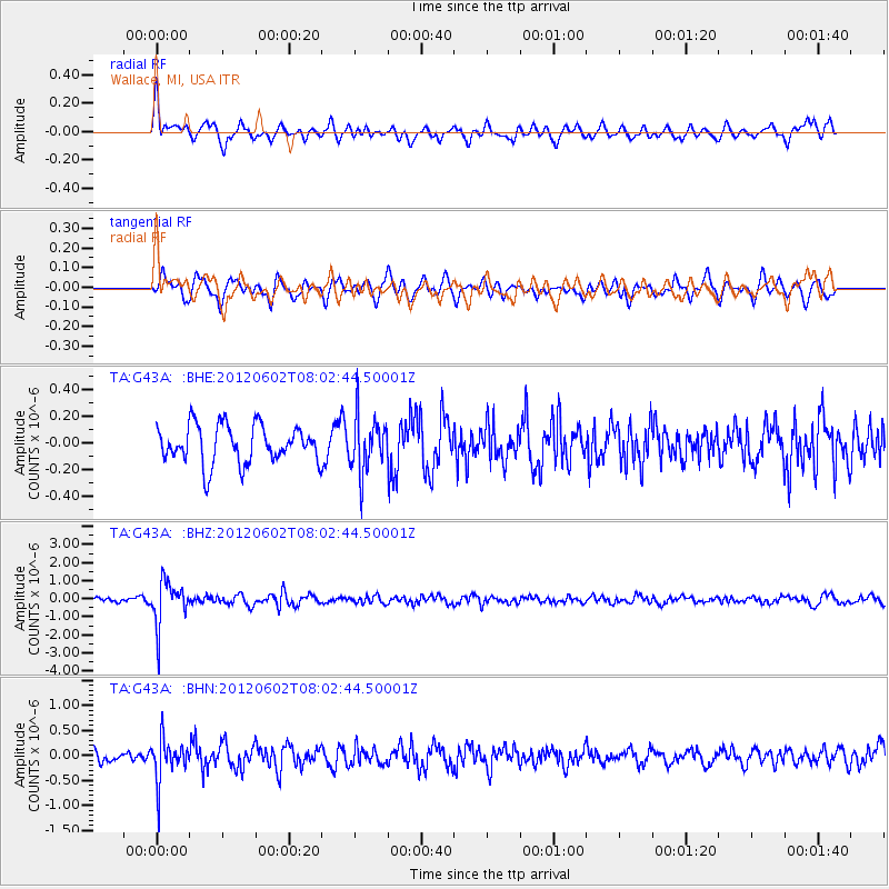
G43A Wallace, MI, USA - Earthquake Result Viewer
*The percent match for this event was below the threshold and hence no stack was calculated.
| Earthquake location: |
Salta Province, Argentina |
| Earthquake latitude/longitude: |
-22.1/-63.6 |
| Earthquake time(UTC): |
2012/06/02 (154) 07:52:53 GMT |
| Earthquake Depth: |
527 km |
| Earthquake Magnitude: |
5.8 MB, 5.9 MW, 6.0 MW |
| Earthquake Catalog/Contributor: |
WHDF/NEIC |
|
| Network: |
TA USArray Transportable Network (new EarthScope stations) |
| Station: |
G43A Wallace, MI, USA |
| Lat/Lon: |
45.26 N/87.69 W |
| Elevation: |
213 m |
|
| Distance: |
70.5 deg |
| Az: |
342.163 deg |
| Baz: |
156.278 deg |
| Ray Param: |
$rayparam |
*The percent match for this event was below the threshold and hence was not used in the summary stack. |
|
| Radial Match: |
64.26969 % |
| Radial Bump: |
400 |
| Transverse Match: |
72.73893 % |
| Transverse Bump: |
400 |
| SOD ConfigId: |
455246 |
| Insert Time: |
2012-09-25 05:11:28.384 +0000 |
| GWidth: |
2.5 |
| Max Bumps: |
400 |
| Tol: |
0.001 |
|
Signal To Noise
| Channel | StoN | STA | LTA |
| TA:G43A: :BHZ:20120602T08:02:44.50001Z | 8.161369 | 1.2154704E-6 | 1.4892971E-7 |
| TA:G43A: :BHN:20120602T08:02:44.50001Z | 3.7554283 | 4.205599E-7 | 1.119872E-7 |
| TA:G43A: :BHE:20120602T08:02:44.50001Z | 1.4597825 | 2.0746006E-7 | 1.4211712E-7 |
| Arrivals |
| Ps | |
| PpPs | |
| PsPs/PpSs | |


