You are here: Home > Network List > G - GEOSCOPE Stations List
> Station SCZ Chualar Canyon, Santa Cruz, California, U.S.A. > Earthquake Result Viewer
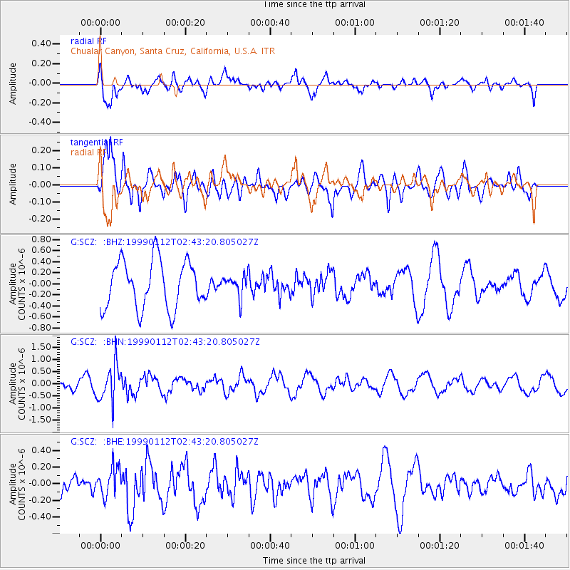
SCZ Chualar Canyon, Santa Cruz, California, U.S.A. - Earthquake Result Viewer
*The percent match for this event was below the threshold and hence no stack was calculated.
| Earthquake location: |
Bonin Islands, Japan Region |
| Earthquake latitude/longitude: |
26.7/140.2 |
| Earthquake time(UTC): |
1999/01/12 (012) 02:32:25 GMT |
| Earthquake Depth: |
441 km |
| Earthquake Magnitude: |
5.9 MB, 6.1 MW, 5.9 MW |
| Earthquake Catalog/Contributor: |
WHDF/NEIC |
|
| Network: |
G GEOSCOPE |
| Station: |
SCZ Chualar Canyon, Santa Cruz, California, U.S.A. |
| Lat/Lon: |
36.60 N/121.40 W |
| Elevation: |
261 m |
|
| Distance: |
80.8 deg |
| Az: |
53.753 deg |
| Baz: |
296.34 deg |
| Ray Param: |
$rayparam |
*The percent match for this event was below the threshold and hence was not used in the summary stack. |
|
| Radial Match: |
57.88252 % |
| Radial Bump: |
400 |
| Transverse Match: |
60.954655 % |
| Transverse Bump: |
400 |
| SOD ConfigId: |
4480 |
| Insert Time: |
2010-02-26 23:55:01.482 +0000 |
| GWidth: |
2.5 |
| Max Bumps: |
400 |
| Tol: |
0.001 |
|
Signal To Noise
| Channel | StoN | STA | LTA |
| G:SCZ: :BHN:19990112T02:43:20.805027Z | 3.212277 | 7.694094E-7 | 2.395215E-7 |
| G:SCZ: :BHE:19990112T02:43:20.805027Z | 0.8857714 | 1.7634564E-7 | 1.9908708E-7 |
| G:SCZ: :BHZ:19990112T02:43:20.805027Z | 0.46473923 | 1.9874891E-7 | 4.2765683E-7 |
| Arrivals |
| Ps | |
| PpPs | |
| PsPs/PpSs | |


