You are here: Home > Network List > US - United States National Seismic Network Stations List
> Station AMTX Amarillo, Texas, USA > Earthquake Result Viewer
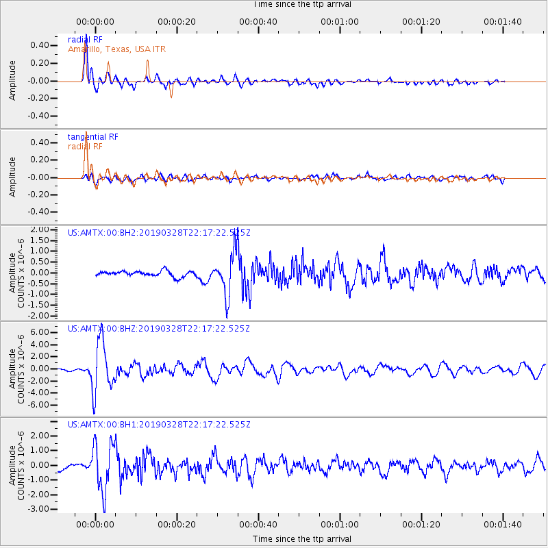
AMTX Amarillo, Texas, USA - Earthquake Result Viewer
*The percent match for this event was below the threshold and hence no stack was calculated.
| Earthquake location: |
East Of Kuril Islands |
| Earthquake latitude/longitude: |
50.5/160.0 |
| Earthquake time(UTC): |
2019/03/28 (087) 22:06:49 GMT |
| Earthquake Depth: |
9.0 km |
| Earthquake Magnitude: |
6.2 Mww |
| Earthquake Catalog/Contributor: |
NEIC PDE/us |
|
| Network: |
US United States National Seismic Network |
| Station: |
AMTX Amarillo, Texas, USA |
| Lat/Lon: |
34.53 N/101.41 W |
| Elevation: |
1010 m |
|
| Distance: |
69.2 deg |
| Az: |
60.829 deg |
| Baz: |
317.516 deg |
| Ray Param: |
$rayparam |
*The percent match for this event was below the threshold and hence was not used in the summary stack. |
|
| Radial Match: |
94.61407 % |
| Radial Bump: |
400 |
| Transverse Match: |
69.8242 % |
| Transverse Bump: |
400 |
| SOD ConfigId: |
3426611 |
| Insert Time: |
2019-04-11 22:26:35.359 +0000 |
| GWidth: |
2.5 |
| Max Bumps: |
400 |
| Tol: |
0.001 |
|
Signal To Noise
| Channel | StoN | STA | LTA |
| US:AMTX:00:BHZ:20190328T22:17:22.525Z | 31.851393 | 4.3383743E-6 | 1.3620674E-7 |
| US:AMTX:00:BH1:20190328T22:17:22.525Z | 9.355221 | 1.6780226E-6 | 1.7936752E-7 |
| US:AMTX:00:BH2:20190328T22:17:22.525Z | 6.837131 | 1.1827284E-6 | 1.7298606E-7 |
| Arrivals |
| Ps | |
| PpPs | |
| PsPs/PpSs | |


