You are here: Home > Network List > TA - USArray Transportable Network (new EarthScope stations) Stations List
> Station U47A Clarksville, TN, USA > Earthquake Result Viewer
U47A Clarksville, TN, USA - Earthquake Result Viewer
| Earthquake location: |
Salta Province, Argentina |
| Earthquake latitude/longitude: |
-22.1/-63.6 |
| Earthquake time(UTC): |
2012/06/02 (154) 07:52:53 GMT |
| Earthquake Depth: |
527 km |
| Earthquake Magnitude: |
5.8 MB, 5.9 MW, 6.0 MW |
| Earthquake Catalog/Contributor: |
WHDF/NEIC |
|
| Network: |
TA USArray Transportable Network (new EarthScope stations) |
| Station: |
U47A Clarksville, TN, USA |
| Lat/Lon: |
36.44 N/87.29 W |
| Elevation: |
145 m |
|
| Distance: |
62.4 deg |
| Az: |
338.508 deg |
| Baz: |
155.071 deg |
| Ray Param: |
0.058313932 |
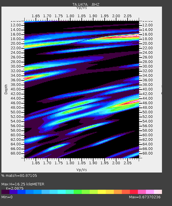
| Estimated Moho Depth: |
16.25 km |
| Estimated Crust Vp/Vs: |
2.09 |
| Assumed Crust Vp: |
6.444 km/s |
| Estimated Crust Vs: |
3.087 km/s |
| Estimated Crust Poisson's Ratio: |
0.35 |
|
| Radial Match: |
80.87105 % |
| Radial Bump: |
400 |
| Transverse Match: |
73.10253 % |
| Transverse Bump: |
400 |
| SOD ConfigId: |
455246 |
| Insert Time: |
2012-09-25 05:16:00.232 +0000 |
| GWidth: |
2.5 |
| Max Bumps: |
400 |
| Tol: |
0.001 |
|

Signal To Noise
| Channel | StoN | STA | LTA |
| TA:U47A: :BHZ:20120602T08:01:54.149973Z | 8.686962 | 1.8670654E-6 | 2.149273E-7 |
| TA:U47A: :BHN:20120602T08:01:54.149973Z | 10.718636 | 1.1521803E-6 | 1.0749318E-7 |
| TA:U47A: :BHE:20120602T08:01:54.149973Z | 4.2429576 | 4.452252E-7 | 1.0493275E-7 |
| Arrivals |
| Ps | 2.8 SECOND |
| PpPs | 7.5 SECOND |
| PsPs/PpSs | 10 SECOND |


