You are here: Home > Network List > TA - USArray Transportable Network (new EarthScope stations) Stations List
> Station Z49A Columbiana, AL, USA > Earthquake Result Viewer
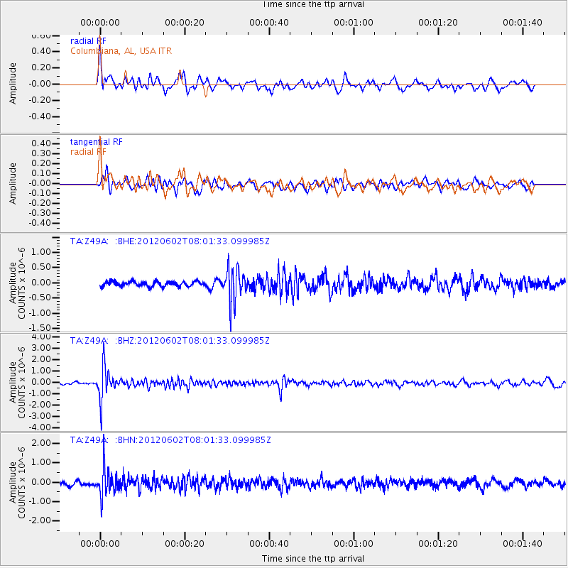
Z49A Columbiana, AL, USA - Earthquake Result Viewer
*The percent match for this event was below the threshold and hence no stack was calculated.
| Earthquake location: |
Salta Province, Argentina |
| Earthquake latitude/longitude: |
-22.1/-63.6 |
| Earthquake time(UTC): |
2012/06/02 (154) 07:52:53 GMT |
| Earthquake Depth: |
527 km |
| Earthquake Magnitude: |
5.8 MB, 5.9 MW, 6.0 MW |
| Earthquake Catalog/Contributor: |
WHDF/NEIC |
|
| Network: |
TA USArray Transportable Network (new EarthScope stations) |
| Station: |
Z49A Columbiana, AL, USA |
| Lat/Lon: |
33.19 N/86.53 W |
| Elevation: |
134 m |
|
| Distance: |
59.2 deg |
| Az: |
337.591 deg |
| Baz: |
155.054 deg |
| Ray Param: |
$rayparam |
*The percent match for this event was below the threshold and hence was not used in the summary stack. |
|
| Radial Match: |
62.169067 % |
| Radial Bump: |
400 |
| Transverse Match: |
50.59757 % |
| Transverse Bump: |
400 |
| SOD ConfigId: |
455246 |
| Insert Time: |
2012-09-25 05:17:12.494 +0000 |
| GWidth: |
2.5 |
| Max Bumps: |
400 |
| Tol: |
0.001 |
|
Signal To Noise
| Channel | StoN | STA | LTA |
| TA:Z49A: :BHZ:20120602T08:01:33.099985Z | 12.874977 | 1.3702122E-6 | 1.0642444E-7 |
| TA:Z49A: :BHN:20120602T08:01:33.099985Z | 5.5632443 | 6.8351636E-7 | 1.228629E-7 |
| TA:Z49A: :BHE:20120602T08:01:33.099985Z | 6.7151213 | 5.336546E-7 | 7.947059E-8 |
| Arrivals |
| Ps | |
| PpPs | |
| PsPs/PpSs | |


