You are here: Home > Network List > US - United States National Seismic Network Stations List
> Station COWI Conover, Wisconsin, USA > Earthquake Result Viewer
COWI Conover, Wisconsin, USA - Earthquake Result Viewer
| Earthquake location: |
East Of Kuril Islands |
| Earthquake latitude/longitude: |
50.5/160.0 |
| Earthquake time(UTC): |
2019/03/28 (087) 22:06:49 GMT |
| Earthquake Depth: |
9.0 km |
| Earthquake Magnitude: |
6.2 Mww |
| Earthquake Catalog/Contributor: |
NEIC PDE/us |
|
| Network: |
US United States National Seismic Network |
| Station: |
COWI Conover, Wisconsin, USA |
| Lat/Lon: |
46.10 N/89.14 W |
| Elevation: |
523 m |
|
| Distance: |
66.8 deg |
| Az: |
45.016 deg |
| Baz: |
319.523 deg |
| Ray Param: |
0.05738851 |
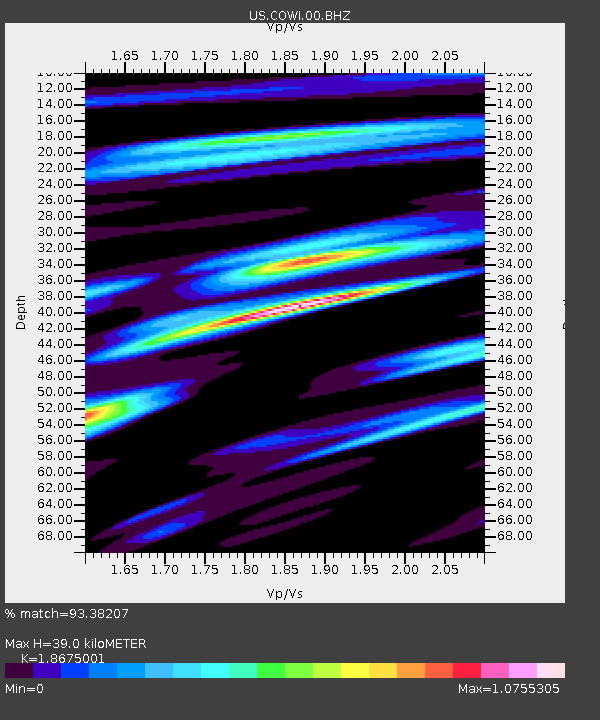
| Estimated Moho Depth: |
39.0 km |
| Estimated Crust Vp/Vs: |
1.87 |
| Assumed Crust Vp: |
6.467 km/s |
| Estimated Crust Vs: |
3.463 km/s |
| Estimated Crust Poisson's Ratio: |
0.30 |
|
| Radial Match: |
93.38207 % |
| Radial Bump: |
328 |
| Transverse Match: |
76.739456 % |
| Transverse Bump: |
400 |
| SOD ConfigId: |
3426611 |
| Insert Time: |
2019-04-11 22:26:50.041 +0000 |
| GWidth: |
2.5 |
| Max Bumps: |
400 |
| Tol: |
0.001 |
|

Signal To Noise
| Channel | StoN | STA | LTA |
| US:COWI:00:BHZ:20190328T22:17:09.923987Z | 28.461927 | 2.9007997E-6 | 1.01918594E-7 |
| US:COWI:00:BH1:20190328T22:17:09.923987Z | 9.186358 | 1.1153603E-6 | 1.2141486E-7 |
| US:COWI:00:BH2:20190328T22:17:09.923987Z | 9.777945 | 9.860055E-7 | 1.00839756E-7 |
| Arrivals |
| Ps | 5.4 SECOND |
| PpPs | 17 SECOND |
| PsPs/PpSs | 22 SECOND |


